IMAGES TAKEN NEAR TO
Dartmouth Terrace, LONDON, SE10 8AX
Introduction
This page details the photographs taken nearby to Dartmouth Terrace, SE10 8AX by members of the Geograph project.
The Geograph project started in 2005 with the aim of publishing, organising and preserving representative images for every square kilometre of Great Britain, Ireland and the Isle of Man.

There are currently over 7.5m images from over14,400 individuals and you can help contribute to the project by visiting https://www.geograph.org.uk
Image Map
Images are licensed for reuse under creativecommons.org/licenses/by-sa/2.0
Notes
- Clicking on the map will re-center to the selected point.
- The higher the marker number, the further away the image location is from the centre of the postcode.
Image Listing (103 Images Found)
Images are licensed for reuse under creativecommons.org/licenses/by-sa/2.0
Image
Details
Distance
1
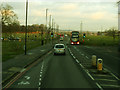
Top of Blackheath Hill
Taken from the bus stop in Image for a view looking down this part of the hill. Normally this road (the A2) is very busy, but tolerably quiet on a Sunday. See also Image
Image: © Stephen Craven
Taken: 18 Jan 2015
0.04 miles
2
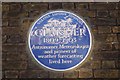
James Claisher Blue Plaque
On 22 Dartmouth Hill.
See http://en.wikipedia.org/wiki/James_Glaisher for more details about the man.
Image: © David Anstiss
Taken: 27 Nov 2009
0.04 miles
3
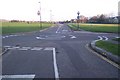
Roundabout on Wat Tyler Road, Blackheath Common
Wat Tyler Road heads right to Lewisham, or left towards the A2 Shooters Hill Road. Hare and Billet Road leads straight on towards Blackheath Vale. Dartmouth Hill heads (behind the viewer) to Dartmouth Row.
Image: © David Anstiss
Taken: 27 Nov 2009
0.04 miles
4
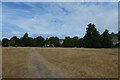
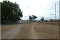
Path on Blackheath Hill
Looking along a path over scorched grass during a prolonged dry spell.
Image: © DS Pugh
Taken: 2 Aug 2022
0.05 miles
5
22 Dartmouth Hill
Has a blue plaque on the wall. See Image for close-up and more details.
Image: © David Anstiss
Taken: 27 Nov 2009
0.05 miles
6
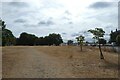
Path near Hyde Vale
Looking along a path over scorched grass during a prolonged dry spell.
Image: © DS Pugh
Taken: 2 Aug 2022
0.05 miles
7
Path beside Blackheath Hill
Looking along a path over scorched grass during a prolonged dry spell.
Image: © DS Pugh
Taken: 2 Aug 2022
0.06 miles
8
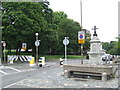
Drinking water, Blackheath
A drinking fountain and cattle trough on Blackheath, in South East London. In the background, a width restriction prevents lorries, coaches and other large vehicles from using the road.
Image: © Malc McDonald
Taken: 23 Jul 2011
0.06 miles
9
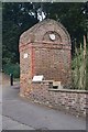
Blackheath : Hyde Valley conduit head, West Grove
Grade II listed structure. Description at this https://historicengland.org.uk/listing/the-list/list-entry/1005548.
Image: © Jim Osley
Taken: 31 Jul 2019
0.07 miles
10
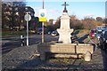
Metropolitan Drinking Fountain and Cattle Trough Association
At the junction of Hyde Vale (on the left) Cade Road (on the right). Cade Road has plenty of commuter parking.
Image: © David Anstiss
Taken: 27 Nov 2009
0.08 miles