IMAGES TAKEN NEAR TO
Billinghurst Way, LONDON, SE10 0XP
Introduction
This page details the photographs taken nearby to Billinghurst Way, SE10 0XP by members of the Geograph project.
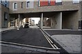
The Geograph project started in 2005 with the aim of publishing, organising and preserving representative images for every square kilometre of Great Britain, Ireland and the Isle of Man.

There are currently over 7.5m images from over14,400 individuals and you can help contribute to the project by visiting https://www.geograph.org.uk
Image Map
Images are licensed for reuse under creativecommons.org/licenses/by-sa/2.0
Notes
- Clicking on the map will re-center to the selected point.
- The higher the marker number, the further away the image location is from the centre of the postcode.
Image Listing (205 Images Found)
Images are licensed for reuse under creativecommons.org/licenses/by-sa/2.0
Image
Details
Distance
1

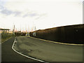
Greenwich Peninsula wasteland
The peninsula is still being developed for various uses, but this patch is still wasteland. In the distance is the Day Aggregates terminal.
Image: © Stephen Craven
Taken: 19 Feb 2012
0.02 miles
2
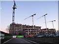
New flats being built on Peartree Way
Several blocks of apartments being built on the narrow strip of land between Peartree Way and Angerstein Wharf gravel unloading terminal Image The developer's blurb promised a development "surrounded by acres of green space" but a quick site visit would be enough to reveal the truth.
Image: © Stephen Craven
Taken: 11 Jan 2014
0.04 miles
3
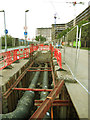
District heating pipes
Pipes being installed on Peartree Way ahead of completion of the development in the background.
Image: © Stephen Craven
Taken: 8 Sep 2014
0.05 miles
4
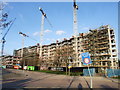
Development on Peartree Way, Greenwich
Image: © Chris Whippet
Taken: 16 Feb 2014
0.05 miles
5
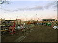
Contractor's compound on Peartree Way
This compound swallowed up part of the road, with a temporary road giving access to the yacht club Image For the building to which it relates, see Image
Image: © Stephen Craven
Taken: 11 Jan 2014
0.06 miles
7
Diversion of Peartree way
Part of the existing road had been swallowed up by a construction site, with this temporary road giving access to the yacht club Image
Image: © Stephen Craven
Taken: 11 Jan 2014
0.06 miles
8
New development on Peartree Way (2)
This development on the Greenwich Peninsula was built in 2014 Image Viewed from Southern Way a few hundred metres to the south-west.
Image: © Stephen Craven
Taken: 22 Apr 2018
0.07 miles
9

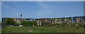
Solar power, Thames path
Solar and wind powered lights on the Thames Path just behind the Greenwich Yacht Club.
Image: © Chris Denny
Taken: 16 Aug 2010
0.07 miles
10
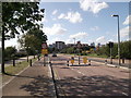
West Parkside, North Greenwich
This road leads from Peartree Way towards the Greenwich Millennium Village (in the background).
Image: © David Anstiss
Taken: 11 Sep 2011
0.07 miles