IMAGES TAKEN NEAR TO
Tunnel Avenue, LONDON, SE10 0US
Introduction
This page details the photographs taken nearby to Tunnel Avenue, SE10 0US by members of the Geograph project.
The Geograph project started in 2005 with the aim of publishing, organising and preserving representative images for every square kilometre of Great Britain, Ireland and the Isle of Man.

There are currently over 7.5m images from over14,400 individuals and you can help contribute to the project by visiting https://www.geograph.org.uk
Image Map
Images are licensed for reuse under creativecommons.org/licenses/by-sa/2.0
Notes
- Clicking on the map will re-center to the selected point.
- The higher the marker number, the further away the image location is from the centre of the postcode.
Image Listing (181 Images Found)
Images are licensed for reuse under creativecommons.org/licenses/by-sa/2.0
Image
Details
Distance
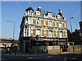
1
The Greenwich Hotel (old fire station)
This is one of two hotels of somewhat faded grandeur at the junction of Tunnel Avenue and Woolwich Road, which has itself lost its importance - see Image The other is the Angerstein Image
The building was originally a fire station and is grade 2 listed (list entry number 1213055).
Image: © Stephen Craven
Taken: 18 Apr 2010
0.00 miles
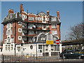
2
Rear of the Greenwich Hotel
The hotel has been closed as such for several years although it seems to be occupied by someone. It would be difficult to demolish it, as the building was originally a fire station and for that reason is grade 2 listed (list entry number 1213055). See Image
Image: © Stephen Craven
Taken: 6 Apr 2013
0.00 miles
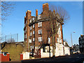
3
The Old Fire Station, East Greenwich
The building was originally a fire station and is grade 2 listed (list entry number 1213055). A few years ago it was called the Greenwich Hotel Image but has now reverted to its former name, though as an apartment block.
The traffic cones in the foreground were in place for the London Marathon that has just passed through.
Image: © Stephen Craven
Taken: 22 Apr 2018
0.01 miles
4
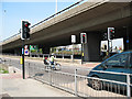
Pelican crossing on the A102 sliproad
It is perhaps unusual to have a Pelican crossing on the sliproad of a major trunk road. But this one forms part of a well-used pedestrian and cycle route giving access to a retail park, the Thames Path and the North Greenwich peninsula generally. For another view of the flyover see Image
Image: © Stephen Craven
Taken: 18 Apr 2010
0.02 miles
5
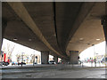
Under the Blackwall Tunnel Approach, Westcombe Park
Image: © David Howard
Taken: 27 Apr 2014
0.02 miles
6
Horn Lane by the Blackwall Tunnel Approach
Image: © David Howard
Taken: 27 Apr 2014
0.02 miles
7
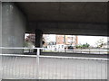
Under the Woolwich Road flyover
A view from underneath the A102 as it crosses Woolwich Road. See Image
Image: © Stephen Craven
Taken: 18 Apr 2010
0.02 miles
8
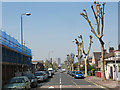
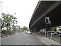
Tunnel Avenue, East Greenwich
This road is now a suburban street with speed humps and a 20mph limit. But its width, straightness and the line of trees along one side are evidence of a grander past, when it was the A102 Blackwall Tunnel approach road. That role (and road number) now belong to the nearby 1970s dual carriageway seen in Image The skyscrapers on the Isle of Dogs on the far side of the Thames can be seen in the distance.
Image: © Stephen Craven
Taken: 18 Apr 2010
0.03 miles
9
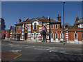
Former East Greenwich Library
Built in 1905 to the designs of Sydney R J Smith in Neo-Classical style, it was a gift to the community by philanthropist Andrew Carnegie. The building is listed grade 2 (list entry number 1213986). See also Image
It was superseded as a public library by the library in the new Greenwich Centre further west along Woolwich Road in 2015 Image The old library building is now up to let.
Image: © Stephen Craven
Taken: 22 Apr 2018
0.03 miles