IMAGES TAKEN NEAR TO
Denford Street, LONDON, SE10 0SA
Introduction
This page details the photographs taken nearby to Denford Street, SE10 0SA by members of the Geograph project.
The Geograph project started in 2005 with the aim of publishing, organising and preserving representative images for every square kilometre of Great Britain, Ireland and the Isle of Man.

There are currently over 7.5m images from over14,400 individuals and you can help contribute to the project by visiting https://www.geograph.org.uk
Image Map
Images are licensed for reuse under creativecommons.org/licenses/by-sa/2.0
Notes
- Clicking on the map will re-center to the selected point.
- The higher the marker number, the further away the image location is from the centre of the postcode.
Image Listing (184 Images Found)
Images are licensed for reuse under creativecommons.org/licenses/by-sa/2.0
Image
Details
Distance
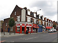
1
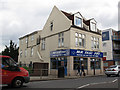
Mister Fast Fry
A fish-and-chip shop on Woolwich Road.
Image: © Stephen Craven
Taken: 9 Jul 2011
0.00 miles
2
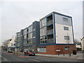
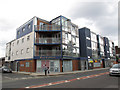
New block on the corner of Fingal Street, Greenwich
A contemporary apartment block on the corner of Fingal Street and Trafalgar Road (the main road).
Image: © Stephen Craven
Taken: 14 Feb 2009
0.01 miles
3
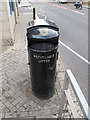
Dual litter bin
Greenwich Council has introduced many bins like this along main roads in recent years. One side is for recyclable litter (paper, cans, bottles) and the other for anything else (food waste etc.). This one is outside a chip shop Image
Image: © Stephen Craven
Taken: 9 Jul 2011
0.02 miles
4
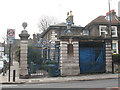
Entrance to former Greenwich Hospital site, Trafalgar Road
The arms on the gateway are those of the Greenwich Hospital (i.e. the naval pensioners' home, now the Old Royal Naval College). I am unsure of what exactly this property was, or what it is now used as.
Image: © Stephen Craven
Taken: 14 Feb 2009
0.03 miles
5
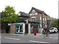
Former Woolwich Road post office
Abans Convenient Store (sic) on the corner of Woolwich Road and Annandale Road still shows evidence of its former life as a post office. There is still a post box outside.
Image: © Stephen Craven
Taken: 9 Jul 2011
0.03 miles
6
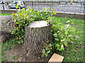
Lime tree stump
The tidied-up stump of a large lime tree in Glenister Gardens that fell in a storm in November 2009. I counted 27 growth rings. There is still flourishing epicormic growth at the base. See also Image
Image: © Stephen Craven
Taken: 9 Jul 2011
0.03 miles
7
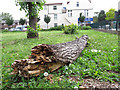
Fallen lime tree trunk
A large lime tree in Glenister Gardens fell in a storm in November 2009. Part of the trunk has been left for biodiversity; this shows the extent of decay after 20 months. Its stump can be seen in the background Image
Image: © Stephen Craven
Taken: 9 Jul 2011
0.04 miles
8
Springwell Day Nursery
The nursery occupies the ground floor of the "Blue Building" on the corner of Fingal Street. It had only opened recently (summer 2011). See Image for the same building earlier.
Image: © Stephen Craven
Taken: 9 Jul 2011
0.04 miles
9
Woolwich Road shops
Shops on the north side of Woolwich Road, east of Fingal Street. As of 2011 they included two fast food takeaways, a grocery and two closed units.
Image: © Stephen Craven
Taken: 9 Jul 2011
0.04 miles
10
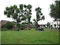
Glenister Gardens
A small public open space alongside Woolwich Road.
Image: © Stephen Craven
Taken: 9 Jul 2011
0.05 miles