IMAGES TAKEN NEAR TO
Blackwall Lane, LONDON, SE10 0RE
Introduction
This page details the photographs taken nearby to Blackwall Lane, SE10 0RE by members of the Geograph project.
The Geograph project started in 2005 with the aim of publishing, organising and preserving representative images for every square kilometre of Great Britain, Ireland and the Isle of Man.

There are currently over 7.5m images from over14,400 individuals and you can help contribute to the project by visiting https://www.geograph.org.uk
Image Map
Images are licensed for reuse under creativecommons.org/licenses/by-sa/2.0
Notes
- Clicking on the map will re-center to the selected point.
- The higher the marker number, the further away the image location is from the centre of the postcode.
Image Listing (230 Images Found)
Images are licensed for reuse under creativecommons.org/licenses/by-sa/2.0
Image
Details
Distance
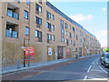
1
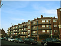
Dyson House
This block of flats occupies two of the three sides of the triangular site between Blackwall Lane and Commerell Place.
Image: © Stephen Craven
Taken: 6 Apr 2013
0.03 miles
2
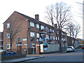
Halley House, Armitage Road, East Greenwich
A block of late 20th century flats.
Image: © Stephen Craven
Taken: 6 Apr 2013
0.04 miles
3
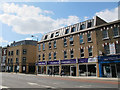
DEBRA shop, Woolwich Road
A larger than usual charity shop with apartments above. The building was erected in 2014 on the site of former council offices - see Image for when it was a demolition site - and in a style matching the older buildings immediately to the east Image
Image: © Stephen Craven
Taken: 16 May 2015
0.04 miles
4
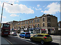
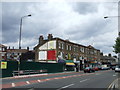
Shops on Woolwich Road
The style of these older buildings was matched by a new one immediately to the west Image
As of May 2015 the businesses (right to left) consisted of a funeral director, estate agent, convenience store, a new Italian restaurant, one vacant unit, cab hire service, kebab shop and dry cleaners. No doubt they would be hoping for business from the large new housing development at Greenwich Square across the road.
Image: © Stephen Craven
Taken: 16 May 2015
0.05 miles
5
Brick detailing on Commerell Place
The side of this house on the corner of Commerell Place includes bricked up doors and windows.
Image: © Stephen Craven
Taken: 6 Apr 2013
0.05 miles
6
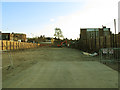
Demolition site in East Greenwich
A site in South East London where a building, or a row of buildings, has been demolished.
Image: © Malc McDonald
Taken: 23 Jul 2011
0.05 miles
7
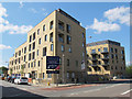
The Peltons, East Greenwich (2)
A block of apartments built in 2014 on a site to the west of Blackwall Lane. It was too long to get the whole of it in one photo but see also Image This end of the site was formerly occupied by a bakery and other shops Image By summer 2015 some of the flats were occupied but the ground floor retail units still vacant.
The bus stop in the middle of the photo serves routes 188 and 422 towards the O2 / North Greenwich transport interchange.
Image: © Stephen Craven
Taken: 16 May 2015
0.05 miles
8
Demolition site adjacent to Blackwall Lane
Demolition of existing buildings on this long, thin plot (approx. 120m x 30m) had been completed. They had included the awning shop Image, a bakery and other shops that I had not got round to photographing before they disappeared.
Image: © Stephen Craven
Taken: 6 Apr 2013
0.06 miles
9
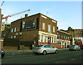
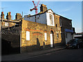
Greenwich Town Social Club
A CIU-affiliated traditional social club on Blackwall Lane.
Image: © Stephen Craven
Taken: 6 Apr 2013
0.06 miles
10
Pelton Terrace, East Greenwich
A pair of blocks of apartments built in 2014/5 on a site to the north of Commerell Street. Unfortunately we don't have a photo of the buildings that formerly occupied the site.
Image: © Stephen Craven
Taken: 16 May 2015
0.06 miles