IMAGES TAKEN NEAR TO
School Square, LONDON, SE10 0QY
Introduction
This page details the photographs taken nearby to School Square, SE10 0QY by members of the Geograph project.
The Geograph project started in 2005 with the aim of publishing, organising and preserving representative images for every square kilometre of Great Britain, Ireland and the Isle of Man.

There are currently over 7.5m images from over14,400 individuals and you can help contribute to the project by visiting https://www.geograph.org.uk
Image Map
Images are licensed for reuse under creativecommons.org/licenses/by-sa/2.0
Notes
- Clicking on the map will re-center to the selected point.
- The higher the marker number, the further away the image location is from the centre of the postcode.
Image Listing (147 Images Found)
Images are licensed for reuse under creativecommons.org/licenses/by-sa/2.0
Image
Details
Distance
1

Illuminated artwork, Greenwich Millennium Village
A pillar in the centre of the square behind Becquerel Court, illuminated at night.
Image: © Stephen Craven
Taken: 20 Feb 2012
0.03 miles
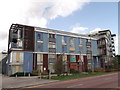
2
Millennium primary school
A primary school intended for the nearby Millennium Village, although I know of pupils from as far away as Eltham.
Image: © Stephen Craven
Taken: 19 Feb 2012
0.06 miles
3
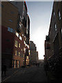
Path to Greenwich Millennium Village
Path beside West Parkside leading towards Greenwich Millennium Village.
Beside a landscaped park beside the new housing development.
Image: © David Anstiss
Taken: 11 Sep 2011
0.07 miles
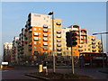
4
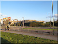
Bus stop on West Parkside
West Parkside, as part of a designed housing development on reclaimed industrial land on the Greenwich Peninsula, has a segregated bus lane. The lanes for other traffic can be seen behind. This stop is served by routes 108, 129, 132, 161, 472 and 486. Apart from 108 (Stratford-Lewisham) all these reoutes start at the North Greenwich transport interchange.
Image: © Stephen Craven
Taken: 19 Apr 2011
0.08 miles
5
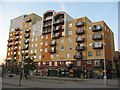
Metcalfe Court shops
A parade of shops occupies the ground floor of Metcalfe Court apartment block on West Parkside on the Greenwich Peninsula. At this time (2011) units included a Nisa convenience store, a pharmacy and dry-cleaner.
Image: © Stephen Craven
Taken: 19 Apr 2011
0.10 miles
6
Greenwich Millennium Village
Another block of the colourful housing development in North Greenwich.
Seen from Southern Way.
Image: © David Anstiss
Taken: 11 Sep 2011
0.10 miles
8
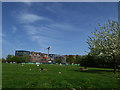
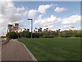
Open space, Greenwich Millennium Village
This appears to be a space that has been protected against the surrounding high-rise developments. Time will tell.
Image: © Stephen Craven
Taken: 22 Apr 2018
0.11 miles
9
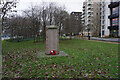
Turf Zone "GrWarMemorial"
East Greenwich Gas Works War Memorial, Central Park, Greenwich.
Image: © Ian S
Taken: 25 Dec 2022
0.12 miles
10
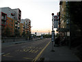
Renaissance Walk
A generally traffic-free street (apart from deliveries etc.) in the Greenwich Millennium Village.
Image: © Stephen Craven
Taken: 17 Feb 2013
0.12 miles