IMAGES TAKEN NEAR TO
Tunnel Avenue, LONDON, SE10 0PF
Introduction
This page details the photographs taken nearby to Tunnel Avenue, SE10 0PF by members of the Geograph project.
The Geograph project started in 2005 with the aim of publishing, organising and preserving representative images for every square kilometre of Great Britain, Ireland and the Isle of Man.

There are currently over 7.5m images from over14,400 individuals and you can help contribute to the project by visiting https://www.geograph.org.uk
Image Map
Images are licensed for reuse under creativecommons.org/licenses/by-sa/2.0
Notes
- Clicking on the map will re-center to the selected point.
- The higher the marker number, the further away the image location is from the centre of the postcode.
Image Listing (179 Images Found)
Images are licensed for reuse under creativecommons.org/licenses/by-sa/2.0
Image
Details
Distance
2
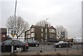
Studio 338, Tunnel Avenue
The former Mitre pub, now a nightclub, previously called THAT Image
Image: © Stephen Craven
Taken: 8 Sep 2014
0.02 miles
3
View from footbridge over Blackwall Road
Image: © Paul Gillett
Taken: 5 Jun 2010
0.02 miles
4
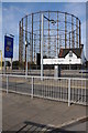
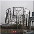
Gasometer beside the A102
Gasometer frame beside the A102 as it approaches the Blackwall Tunnel to the south of Millennium Dome.
Image: © Philip Halling
Taken: 1 Oct 2011
0.03 miles
5
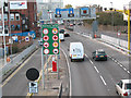
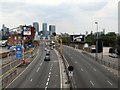
Too much information!
Approaching the Blackwall tunnel south entrance, there are too many signs for a driver to take in. Let's see:
20mph speed limit reminder flashing warning
4m height restriction (in one lane) and 2.8m in the other
Seven different signs banning particular substances
Prohibited vehicles [turn off here]
Lane closed (contraflow lane)
6'6" width restriction (for when the contraflow lane is in operation)
- and did you spot the hidden Gatso speed camera behind the sign board, and the average-speed CCTV cameras above the road?
Image: © Stephen Craven
Taken: 7 Nov 2009
0.03 miles
6
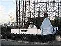
THAT club
An isolated building on the Blackwall Tunnel approach road, formerly a pub called The Mitre, now a nightclub called THAT.
Update: the building (by then called Studio 338) was destroyed by fire on 8 August 2016.
Image: © Stephen Craven
Taken: 7 Nov 2009
0.04 miles
7
Thames Path abandons the river
At this point any riverside possibilities have vanished and one is directed towards the Brenntag Building and the Blackwall Tunnel approach road, passing a gravel works for added interest.
Image: © Chris Denny
Taken: 16 Aug 2010
0.04 miles
8
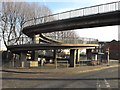
Footbridge approach, SE10
This footbridge over the Blackwall Tunnel southern approach road has a spiral form on the eastern side.
Image: © Peter Thwaite
Taken: 20 Dec 2008
0.04 miles
9
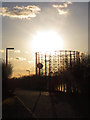
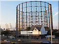
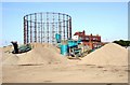
Gasholder against the sun
The remaining gasholder structure on the Greenwich Peninsula, silhouetted against the afternoon sunshine.
Image: © Stephen Craven
Taken: 19 Feb 2012
0.04 miles