IMAGES TAKEN NEAR TO
Banning Street, LONDON, SE10 0NY
Introduction
This page details the photographs taken nearby to Banning Street, SE10 0NY by members of the Geograph project.
The Geograph project started in 2005 with the aim of publishing, organising and preserving representative images for every square kilometre of Great Britain, Ireland and the Isle of Man.

There are currently over 7.5m images from over14,400 individuals and you can help contribute to the project by visiting https://www.geograph.org.uk
Image Map
Images are licensed for reuse under creativecommons.org/licenses/by-sa/2.0
Notes
- Clicking on the map will re-center to the selected point.
- The higher the marker number, the further away the image location is from the centre of the postcode.
Image Listing (364 Images Found)
Images are licensed for reuse under creativecommons.org/licenses/by-sa/2.0
Image
Details
Distance
1
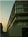
New housing on Banning Street
Several new blocks of apartments have been constructed on this former industrial site in recent years, such as this one in the acute angle between Banning Street and Derwent Street.
Image: © Stephen Craven
Taken: 6 Apr 2013
0.02 miles
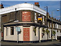
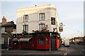
2
The Pelton Arms
On the junction of Banning Street and Pelton Road.
Image: © Peter Trimming
Taken: 29 Aug 2009
0.03 miles
3
Granite Apartments, Banning Street, Greenwich
Part of a modern apartment block named after the nearby wharf and occupying the historic site of the stone works - see Image
Image: © Stephen Craven
Taken: 3 Oct 2015
0.03 miles
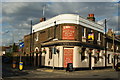
4
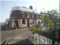
The Nags Head, aka The Pelton Arms, East Greenwich
This public house is really The Pelton Arms as seen over the door. However, when the Only Fools and Horses prequel 'Rock and Chips' was being filmed in nearby Caradoc Street, The Pelton Arms stood in for The Nags Head. This appeared just on the side of the pub adjoining Pelton Road, but, as can be seen here, the name has been kept.
Image: © Marathon
Taken: 8 Apr 2011
0.04 miles
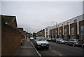
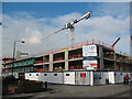
6
Lovell's Wharf Building SE10
This area is under major redevelopment
Image: © Robin Sones
Taken: 28 Apr 2007
0.04 miles
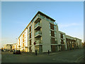
7
Lovell's Wharf housing development (2)
A major residential development, by London & Quadrant Housing Association, on a former industrial site between Christchurch Way and the River Thames. See also Image
Image: © Stephen Craven
Taken: 14 Feb 2009
0.04 miles
8
The Royal Standard
Greenwich hostelry on the corner of Christchurch Way and Pelton Road
Image: © Richard Croft
Taken: 31 Jan 2009
0.04 miles