IMAGES TAKEN NEAR TO
Halstow Road, LONDON, SE10 0LD
Introduction
This page details the photographs taken nearby to Halstow Road, SE10 0LD by members of the Geograph project.
The Geograph project started in 2005 with the aim of publishing, organising and preserving representative images for every square kilometre of Great Britain, Ireland and the Isle of Man.

There are currently over 7.5m images from over14,400 individuals and you can help contribute to the project by visiting https://www.geograph.org.uk
Image Map
Images are licensed for reuse under creativecommons.org/licenses/by-sa/2.0
Notes
- Clicking on the map will re-center to the selected point.
- The higher the marker number, the further away the image location is from the centre of the postcode.
Image Listing (181 Images Found)
Images are licensed for reuse under creativecommons.org/licenses/by-sa/2.0
Image
Details
Distance
1
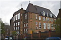
Halstow Primary School, seen from Halstow Road
Image: © David Martin
Taken: 8 Jan 2023
0.02 miles
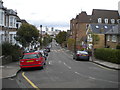
2
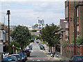
Looking down Halstow Road
A view northwards from the railway bridge. Halstow primary school on the right.
Image: © Stephen Craven
Taken: 9 Jul 2011
0.02 miles
3
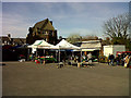
Farmers market at Halstow School
A new venture for 2011 was a Saturday morning farmers' market in the school playground.
Image: © Stephen Craven
Taken: 12 Mar 2011
0.03 miles
4
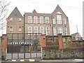
Halstow Primary School, Greenwich
This is the rear view of the school from Kemsing Road to the east. The main entrance is on Halstow Road, but the width of the playground means that this is the best view of the full height of the building. For another example of this style of school architecture in the area, see Image
Image: © Stephen Craven
Taken: 14 Feb 2009
0.03 miles
5
Halstow Road, Greenwich
Looking towards Woolwich Road from Ormiston Road.
Image: © Richard Vince
Taken: 28 Sep 2019
0.04 miles
6
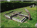
Grave with anchor
This unusual form of grave marker in East Greenwich Pleasaunce reflects the fact that most of those buried here were seamen from the nearby Royal Naval College. But there are also allusions to the Christian hope of afterlife, of which the anchor is a traditional symbol.
Image: © Stephen Craven
Taken: 9 Jul 2011
0.04 miles
7
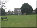
East Greenwich Pleasaunce: open grassland
The Pleasaunce, a former burial ground, is made up of several distinct zones. For other photos of the park, see http://www.geograph.org.uk/search.php?i=5305648
Image: © Stephen Craven
Taken: 14 Feb 2009
0.05 miles
8
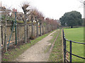
East Greenwich Pleasaunce: north side
The trees along this side of the park are pleached limes. Pleaching is a technique of training the branches of a row of trees along horizontal wires to form a kind of suspended hedge when they are in leaf. For other photos of the park see http://www.geograph.org.uk/search.php?i=5305648, and for a list of other species of trees in the park see http://www.greenwich.gov.uk/Greenwich/YourEnvironment/GreenSpace/ParksGardens/Greenwich/EastGreenwichPleasaunce.htm
Image: © Stephen Craven
Taken: 14 Feb 2009
0.05 miles
9
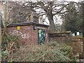
Electricity substation, Halstow Road
The substation is adjacent to the entrance to the Pleasaunce.
Image: © Stephen Craven
Taken: 14 Feb 2009
0.05 miles
10
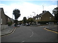
Ormiston Road, Greenwich
Seen from the northern part of Halstow Road, which continues south as the road ahead on the right.
Image: © Richard Vince
Taken: 28 Sep 2019
0.06 miles