IMAGES TAKEN NEAR TO
Annandale Road, LONDON, SE10 0JY
Introduction
This page details the photographs taken nearby to Annandale Road, SE10 0JY by members of the Geograph project.
The Geograph project started in 2005 with the aim of publishing, organising and preserving representative images for every square kilometre of Great Britain, Ireland and the Isle of Man.

There are currently over 7.5m images from over14,400 individuals and you can help contribute to the project by visiting https://www.geograph.org.uk
Image Map
Images are licensed for reuse under creativecommons.org/licenses/by-sa/2.0
Notes
- Clicking on the map will re-center to the selected point.
- The higher the marker number, the further away the image location is from the centre of the postcode.
Image Listing (202 Images Found)
Images are licensed for reuse under creativecommons.org/licenses/by-sa/2.0
Image
Details
Distance
1
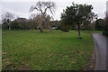
East Greenwich Pleasaunce: closed toilets
Like many public toilets, this block has been permanently closed in recent years.
Image: © Stephen Craven
Taken: 14 Feb 2009
0.03 miles
2
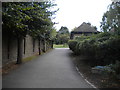
Footpath into East Greenwich Plesaunce, Greenwich
From Chevening Road.
Image: © Richard Vince
Taken: 28 Sep 2019
0.04 miles
3
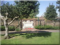
Memorial tablet near the entrance to East Greenwich Pleasaunce
East Greenwich Pleasaunce is one of the more unusual parks in south east London. It opened as a park in 1857 but in 1875 the remains of some 3,000 sailors and officers were removed from their previous burial ground at the Royal Hospital for Seamen at Greenwich, due to the construction of a railway tunnel. The west plot has seamen and the east plot has officers according to naval etiquette. In 1926 the Admiralty sold the Pleasaunce to the Metropolitan Borough of Greenwich, keeping the right for further burials. Railings were removed and the Pleasaunce was landscaped as a park. Today it is the unusual combination of a graveyard and a park. This view is near the entrance where the tablet relays the details of the burials.
Image: © Marathon
Taken: 7 Apr 2011
0.05 miles
4
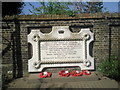
Memorial tablet in East Greenwich Pleasaunce
East Greenwich Pleasaunce is one of the more unusual parks in south east London. It opened as a park in 1857 but in 1875 the remains of some 3,000 sailors and officers were removed from their previous burial ground at the Royal Hospital for Seamen at Greenwich, due to the construction of a railway tunnel. The west plot has seamen and the east plot has officers according to naval etiquette. In 1926 the Admiralty sold the Pleasaunce to the Metropolitan Borough of Greenwich, keeping the right for further burials. Railings were removed and the Pleasaunce was landscaped as a park. Today it is the unusual combination of a graveyard and a park. This tablet is on the western wall, close to the entrance.
Image: © Marathon
Taken: 7 Apr 2011
0.05 miles
5
Turf Zone "Pleasaunce"
At East Greenwich Pleasaunce, Greenwich.
Image: © Ian S
Taken: 25 Dec 2022
0.05 miles
6
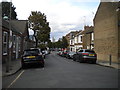
Chevening Road, Greenwich (1)
Looking towards Woolwich Road.
Image: © Richard Vince
Taken: 28 Sep 2019
0.05 miles
7
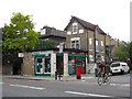
Former Woolwich Road post office
Abans Convenient Store (sic) on the corner of Woolwich Road and Annandale Road still shows evidence of its former life as a post office. There is still a post box outside.
Image: © Stephen Craven
Taken: 9 Jul 2011
0.06 miles
8
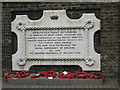
Memorial to the Greenwich Royal Hospital Pensioners
The memorial, and the mass grave to which it refers, are in the East Greenwich Pleasaunce. http://www.geograph.org.uk/search.php?i=5305648
Image: © Stephen Craven
Taken: 14 Feb 2009
0.06 miles
9
Chevening Road, Greenwich (2)
Looking towards Halstow Road.
Image: © Richard Vince
Taken: 28 Sep 2019
0.06 miles
10
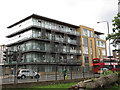
Apartments on Woolwich Road
A fairly recent residential development on the south side of the main road, just west of Annandale Road. There is a Pelican crossing to the left of the photo.
Image: © Stephen Craven
Taken: 9 Jul 2011
0.06 miles