IMAGES TAKEN NEAR TO
Woolwich Road, LONDON, SE10 0JU
Introduction
This page details the photographs taken nearby to Woolwich Road, SE10 0JU by members of the Geograph project.
The Geograph project started in 2005 with the aim of publishing, organising and preserving representative images for every square kilometre of Great Britain, Ireland and the Isle of Man.

There are currently over 7.5m images from over14,400 individuals and you can help contribute to the project by visiting https://www.geograph.org.uk
Image Map
Images are licensed for reuse under creativecommons.org/licenses/by-sa/2.0
Notes
- Clicking on the map will re-center to the selected point.
- The higher the marker number, the further away the image location is from the centre of the postcode.
Image Listing (192 Images Found)
Images are licensed for reuse under creativecommons.org/licenses/by-sa/2.0
Image
Details
Distance
1

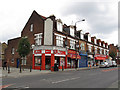
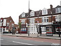
The River Ale House, East Greenwich
This micropub has opened within the last couple of years on the corner of Woolwich Road and Marlton Street. I can't recall what the building was last used as. But it's already in the Good Beer Guide.
The man to the right of the photo is a volunteer marshal for the London Marathon, whose runners had already finished passing this point.
Image: © Stephen Craven
Taken: 22 Apr 2018
0.01 miles
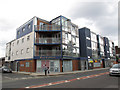
2
Woolwich Road shops
Shops on the north side of Woolwich Road, east of Fingal Street. As of 2011 they included two fast food takeaways, a grocery and two closed units.
Image: © Stephen Craven
Taken: 9 Jul 2011
0.02 miles
3
Springwell Day Nursery
The nursery occupies the ground floor of the "Blue Building" on the corner of Fingal Street. It had only opened recently (summer 2011). See Image for the same building earlier.
Image: © Stephen Craven
Taken: 9 Jul 2011
0.02 miles
4
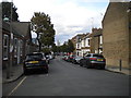
Chevening Road, Greenwich (1)
Looking towards Woolwich Road.
Image: © Richard Vince
Taken: 28 Sep 2019
0.04 miles
5
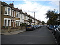
Chevening Road, Greenwich (2)
Looking towards Halstow Road.
Image: © Richard Vince
Taken: 28 Sep 2019
0.04 miles
6
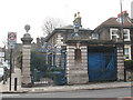
Entrance to former Greenwich Hospital site, Trafalgar Road
The arms on the gateway are those of the Greenwich Hospital (i.e. the naval pensioners' home, now the Old Royal Naval College). I am unsure of what exactly this property was, or what it is now used as.
Image: © Stephen Craven
Taken: 14 Feb 2009
0.04 miles
7
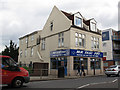
Shops on Woolwich Road, Westcombe Park
The two in the middle are now residential use.
Image: © David Howard
Taken: 27 Apr 2014
0.05 miles
8
East Greenwich Pleasaunce: closed toilets
Like many public toilets, this block has been permanently closed in recent years.
Image: © Stephen Craven
Taken: 14 Feb 2009
0.06 miles
9
Mister Fast Fry
A fish-and-chip shop on Woolwich Road.
Image: © Stephen Craven
Taken: 9 Jul 2011
0.06 miles
10
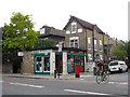
Former Woolwich Road post office
Abans Convenient Store (sic) on the corner of Woolwich Road and Annandale Road still shows evidence of its former life as a post office. There is still a post box outside.
Image: © Stephen Craven
Taken: 9 Jul 2011
0.06 miles