IMAGES TAKEN NEAR TO
Peartree Way, LONDON, SE10 0HZ
Introduction
This page details the photographs taken nearby to Peartree Way, SE10 0HZ by members of the Geograph project.
The Geograph project started in 2005 with the aim of publishing, organising and preserving representative images for every square kilometre of Great Britain, Ireland and the Isle of Man.

There are currently over 7.5m images from over14,400 individuals and you can help contribute to the project by visiting https://www.geograph.org.uk
Image Map
Images are licensed for reuse under creativecommons.org/licenses/by-sa/2.0
Notes
- Clicking on the map will re-center to the selected point.
- The higher the marker number, the further away the image location is from the centre of the postcode.
Image Listing (177 Images Found)
Images are licensed for reuse under creativecommons.org/licenses/by-sa/2.0
Image
Details
Distance
1
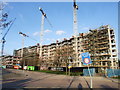
Development on Peartree Way, Greenwich
Image: © Chris Whippet
Taken: 16 Feb 2014
0.01 miles
2
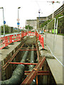
District heating pipes
Pipes being installed on Peartree Way ahead of completion of the development in the background.
Image: © Stephen Craven
Taken: 8 Sep 2014
0.02 miles
3
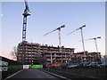
New flats being built on Peartree Way
Several blocks of apartments being built on the narrow strip of land between Peartree Way and Angerstein Wharf gravel unloading terminal Image The developer's blurb promised a development "surrounded by acres of green space" but a quick site visit would be enough to reveal the truth.
Image: © Stephen Craven
Taken: 11 Jan 2014
0.03 miles
4
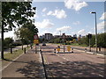
West Parkside, North Greenwich
This road leads from Peartree Way towards the Greenwich Millennium Village (in the background).
Image: © David Anstiss
Taken: 11 Sep 2011
0.04 miles
5

New development on Peartree Way
This development on the Greenwich Peninsula is so new that it is not shown on maps yet. Viewed from Southern Way a couple of hundred metres to the west.
Image: © Stephen Craven
Taken: 22 Apr 2018
0.07 miles
6
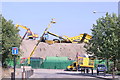
Dancing cranes and diggers
A busy industrial scene just off Pear Tree Way on the Greenwich Peninsula.
Image: © Chris Denny
Taken: 16 Aug 2010
0.08 miles
7

Greenwich Peninsula wasteland
The peninsula is still being developed for various uses, but this patch is still wasteland. In the distance is the Day Aggregates terminal.
Image: © Stephen Craven
Taken: 19 Feb 2012
0.08 miles
8
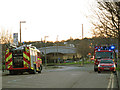
Fire engines on Peartree Way
Two of four fire appliances called out to a fire in a waste recycling plant Image
Image: © Stephen Craven
Taken: 11 Jan 2014
0.09 miles
9

Industrial structure, off Pear Tree Way
I have no idea what it might be but it is impressively tall with pipes and staircases and lots of other bits and pieces.
Image: © Chris Denny
Taken: 16 Aug 2010
0.10 miles
10
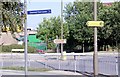
Which way to Greenwich?
A potentially confusing selection of signs on Pear Tree Way, one of many industrial link roads in the Greenwich peninsula area.
Image: © Chris Denny
Taken: 16 Aug 2010
0.11 miles