IMAGES TAKEN NEAR TO
River Gardens Walk, LONDON, SE10 0GB
Introduction
This page details the photographs taken nearby to River Gardens Walk, SE10 0GB by members of the Geograph project.
The Geograph project started in 2005 with the aim of publishing, organising and preserving representative images for every square kilometre of Great Britain, Ireland and the Isle of Man.

There are currently over 7.5m images from over14,400 individuals and you can help contribute to the project by visiting https://www.geograph.org.uk
Image Map
Images are licensed for reuse under creativecommons.org/licenses/by-sa/2.0
Notes
- Clicking on the map will re-center to the selected point.
- The higher the marker number, the further away the image location is from the centre of the postcode.
Image Listing (386 Images Found)
Images are licensed for reuse under creativecommons.org/licenses/by-sa/2.0
Image
Details
Distance
1
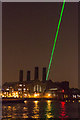
River Thames with Laser Meridian Line, Greenwich, at Night
The power station can be seen silhouetted against the sky.
Image: © Christine Matthews
Taken: 3 Oct 2015
0.01 miles
2
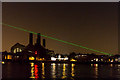
River Thames with Laser Meridian Line, Greenwich, at Night
The power station can be seen silhouetted against the sky.
Image: © Christine Matthews
Taken: 3 Oct 2015
0.01 miles
3
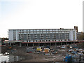
Nobody is About
Very empty on a weekday. The only people you see are builders putting up yet more housing.
Image: © Des Blenkinsopp
Taken: 22 May 2018
0.01 miles
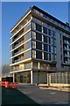
4
Granite Wharf development, Greenwich
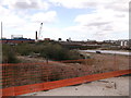
The first block on the former Granite Wharf site. The site is so named because of the stone trade carried out there, and it is famous for where the Swanage Globe Image was made. Because of the 2008/9 recession the rest of the site was still vacant.
Image: © Stephen Craven
Taken: 7 Nov 2009
0.02 miles
5
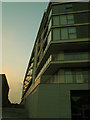
Granite Apartments, Banning Street, Greenwich
Part of a modern apartment block named after the nearby wharf and occupying the historic site of the stone works - see Image
Image: © Stephen Craven
Taken: 3 Oct 2015
0.02 miles
7
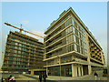
Riverside Gardens, Greenwich
Otherwise known as Phase 1 of Lovells Wharf (Phase 2 is in construction in the background).
Image: © Stephen Craven
Taken: 3 Oct 2015
0.03 miles
8
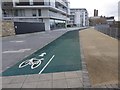
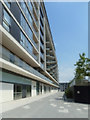
Cycleway at River Gardens
This length of purpose-built cycleway forms part of both the 296 kilometre Thames Path, a National Trail for walkers, and route 1 of the National Cycle Network, an even longer cycle route which runs from Shetland to Dover. The "River Gardens" comprise several new apartment blocks along the waterfront.
Image: © Oliver Dixon
Taken: 21 Dec 2015
0.03 miles
9
Lovell's Wharf, Greenwich
Former site of Thames riverside industrial buildings.
Due to be developed into Riverside apartments sometime!
Due to this non-construction site, the Thames Path (long distance path) has to leave the river.
Image: © David Anstiss
Taken: 11 Sep 2011
0.03 miles
10
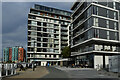
Riverside living
Modern apartment buildings with ground floor businesses along the Thames Path.
Image: © David Martin
Taken: 17 Oct 2021
0.03 miles