IMAGES TAKEN NEAR TO
Pelton Road, LONDON, SE10 0FG
Introduction
This page details the photographs taken nearby to Pelton Road, SE10 0FG by members of the Geograph project.
The Geograph project started in 2005 with the aim of publishing, organising and preserving representative images for every square kilometre of Great Britain, Ireland and the Isle of Man.

There are currently over 7.5m images from over14,400 individuals and you can help contribute to the project by visiting https://www.geograph.org.uk
Image Map
Images are licensed for reuse under creativecommons.org/licenses/by-sa/2.0
Notes
- Clicking on the map will re-center to the selected point.
- The higher the marker number, the further away the image location is from the centre of the postcode.
Image Listing (419 Images Found)
Images are licensed for reuse under creativecommons.org/licenses/by-sa/2.0
Image
Details
Distance
1
Pelton Road, looking east
Seen in evening sunlight, which brings out the quality of the road surface Image
Image: © Stephen Craven
Taken: 31 May 2013
0.02 miles
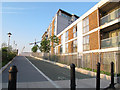
2
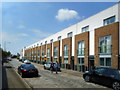
New low-rise for a change
Unashamedly modern but keeping the scale of a traditional terraced street rather than just another block.
Image: © Des Blenkinsopp
Taken: 22 May 2018
0.02 miles
3
The Thames Path by the River Gardens
The River Gardens at Royal Greenwich is a vibrant new quarter stretching 300 metres along the banks of the River Thames.
Image: © Steve Daniels
Taken: 6 Sep 2013
0.02 miles
4

New apartments on Pelton Road
The River Gardens at Royal Greenwich is a vibrant new quarter stretching 300 metres along the banks of the River Thames.
Image: © Steve Daniels
Taken: 6 Sep 2013
0.02 miles
5
Thames path, east of Ballast Quay
This is a well built section of segregated pedestrian and cycle paths, east of Ballast Quay Image, but at present only runs a short way before meeting an obstruction Image
Image: © Stephen Craven
Taken: 31 May 2013
0.02 miles
6
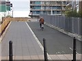
Cycleway at River Gardens
Forming part of both the 296 kilometre Thames Path, a National Trail for walkers, and route 1 of the National Cycle Network, an even longer cycle route which runs from Shetland to Dover. The "River Gardens" comprise several new apartment blocks seen in the background.
Image: © Oliver Dixon
Taken: 21 Dec 2015
0.02 miles
7
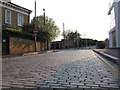
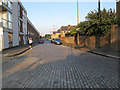
Listed road surface, Pelton Road
It is unusual for a road surface, rather than a building or other above-ground structure to be listed. But Pelton Road and a few surrounding streets are listed grade 2 for the quality of their stone setts, and the local connection that the granite was unloaded from ships at a local wharf. List entry number 1393679.
Image: © Stephen Craven
Taken: 31 May 2013
0.02 miles
8

Dead end at Lovell's Wharf
With phase 2 of the residential Lovell's Wharf development in construction, the Thames Path cycle route Image has been rudely interrupted. For a couple of years there was no access along the riverside at all alongside this development, but as a result of local protests a temporary path was reopened in early 2013 Image
Image: © Stephen Craven
Taken: 31 May 2013
0.02 miles
9
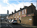
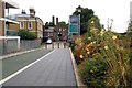
Enderby Street, Greenwich
Classic 'industrial' terraced housing with the power station (now disused) beyond.
Image: © Stephen Craven
Taken: 14 Feb 2009
0.03 miles