IMAGES TAKEN NEAR TO
Greenroof Way, LONDON, SE10 0DQ
Introduction
This page details the photographs taken nearby to Greenroof Way, SE10 0DQ by members of the Geograph project.
The Geograph project started in 2005 with the aim of publishing, organising and preserving representative images for every square kilometre of Great Britain, Ireland and the Isle of Man.

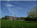
There are currently over 7.5m images from over14,400 individuals and you can help contribute to the project by visiting https://www.geograph.org.uk
Image Map
Images are licensed for reuse under creativecommons.org/licenses/by-sa/2.0
Notes
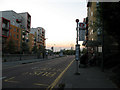
- Clicking on the map will re-center to the selected point.
- The higher the marker number, the further away the image location is from the centre of the postcode.
Image Listing (122 Images Found)
Images are licensed for reuse under creativecommons.org/licenses/by-sa/2.0
Image
Details
Distance
1
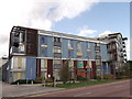
Greenwich Millennium Village
Another block of the colourful housing development in North Greenwich.
Seen from Southern Way.
Image: © David Anstiss
Taken: 11 Sep 2011
0.06 miles
2
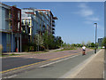
Southern Way, North Greenwich
This road, part of the first phase of development of the Greenwich Peninsula c.2000, is unusual in that it is only used by buses, and cyclists on the segregated cycle track - a vision for car-free living that has sadly not been followed in later developments on the Peninsula.
Image: © Stephen Craven
Taken: 22 Apr 2018
0.06 miles
3

Illuminated artwork, Greenwich Millennium Village
A pillar in the centre of the square behind Becquerel Court, illuminated at night.
Image: © Stephen Craven
Taken: 20 Feb 2012
0.08 miles
4
Path to Greenwich Millennium Village
Path beside West Parkside leading towards Greenwich Millennium Village.
Beside a landscaped park beside the new housing development.
Image: © David Anstiss
Taken: 11 Sep 2011
0.08 miles
5
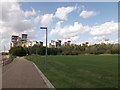
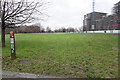
Open space, Greenwich Millennium Village
This appears to be a space that has been protected against the surrounding high-rise developments. Time will tell.
Image: © Stephen Craven
Taken: 22 Apr 2018
0.10 miles
6
Turf Zone "WestParkside"
Southern Park off West Parkside, Greenwich.
Image: © Ian S
Taken: 25 Dec 2022
0.10 miles
7
Millennium primary school
A primary school intended for the nearby Millennium Village, although I know of pupils from as far away as Eltham.
Image: © Stephen Craven
Taken: 19 Feb 2012
0.10 miles
8
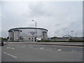
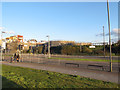
The Odeon Imax on Bugsby's Way, Greenwich
Image: © David Howard
Taken: 27 Apr 2014
0.13 miles
9
Bus stop on West Parkside
West Parkside, as part of a designed housing development on reclaimed industrial land on the Greenwich Peninsula, has a segregated bus lane. The lanes for other traffic can be seen behind. This stop is served by routes 108, 129, 132, 161, 472 and 486. Apart from 108 (Stratford-Lewisham) all these reoutes start at the North Greenwich transport interchange.
Image: © Stephen Craven
Taken: 19 Apr 2011
0.13 miles