IMAGES TAKEN NEAR TO
Calvert Road, LONDON, SE10 0DG
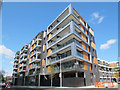
Introduction
This page details the photographs taken nearby to Calvert Road, SE10 0DG by members of the Geograph project.
The Geograph project started in 2005 with the aim of publishing, organising and preserving representative images for every square kilometre of Great Britain, Ireland and the Isle of Man.

There are currently over 7.5m images from over14,400 individuals and you can help contribute to the project by visiting https://www.geograph.org.uk
Image Map
Images are licensed for reuse under creativecommons.org/licenses/by-sa/2.0
Notes
- Clicking on the map will re-center to the selected point.
- The higher the marker number, the further away the image location is from the centre of the postcode.
Image Listing (201 Images Found)
Images are licensed for reuse under creativecommons.org/licenses/by-sa/2.0
Image
Details
Distance
1
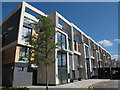
Greenwich Square, block 4
Block 4, consisting of two-storey maisonettes, was among the first part of the site to be occupied.
Image: © Stephen Craven
Taken: 16 May 2015
0.02 miles
2
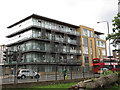
Apartments on Woolwich Road
A fairly recent residential development on the south side of the main road, just west of Annandale Road. There is a Pelican crossing to the left of the photo.
Image: © Stephen Craven
Taken: 9 Jul 2011
0.03 miles
3
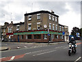
Wing Wah Buffet
This restaurant on the corner of Woolwich Road and Calvert Road is evidence of a large Chinese community in East Greenwich.
Image: © Stephen Craven
Taken: 9 Jul 2011
0.04 miles
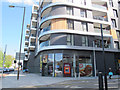
4
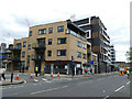
New building on the corner of Calvert Road
This site was formerly occupied by the Wing Wah Buffet Image The ground floor of the new block was to be occupied by the Haven nail bar ("grand opening 9th May 2019").
Image: © Stephen Craven
Taken: 28 Apr 2019
0.04 miles
5
Greenwich Square, block 2
Block 2, consisting of retail units with apartments above, was among the first part of the site to be occupied.
Image: © Stephen Craven
Taken: 16 May 2015
0.05 miles
6
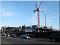
Greenwich Square under construction (2)
Since my previous photo three months earlier of this large construction site Image the development had changed its name from "heart of East Greenwich" (geographically accurate) to Greenwich Square" (probably meant to be more aspirational, sounding as if it is in the town centre, not a mile away).
Image: © Stephen Craven
Taken: 6 Apr 2013
0.05 miles
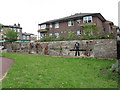
7
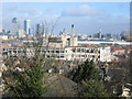
The derelict Greenwich Regional Hospital before demolition
Despite the bulk of the hospital the view is still dominated by Canary Wharf.
Image: © Rachel Bowles
Taken: 28 Mar 2006
0.06 miles
8
Greenwich Square, Sainsbury's Local
The first shop to open in the development, in the ground floor of Block 2 on the corner of Hazel Lane. Surprisingly there are no cycle stands provided as are usually provided for new shops these days.
Image: © Stephen Craven
Taken: 16 May 2015
0.06 miles
9
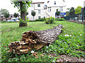
Fallen lime tree trunk
A large lime tree in Glenister Gardens fell in a storm in November 2009. Part of the trunk has been left for biodiversity; this shows the extent of decay after 20 months. Its stump can be seen in the background Image
Image: © Stephen Craven
Taken: 9 Jul 2011
0.06 miles
10
Thames Workers mural in Glenister Gardens
A mural with scenes from life along the river - boats and people. The medium is natural stones and various forms of ceramics and terracotta set into concrete panels. The artist was Philippa Threlfall and she originally made it in 1974 for the nearby Greenwich District Hospital. After the hospital closed, it was relocated in 2007 to its present site at the west end of Glenister Gardens.
Image: © Stephen Craven
Taken: 9 Jul 2011
0.06 miles