IMAGES TAKEN NEAR TO
Calvert Road, LONDON, SE10 0DF
Introduction
This page details the photographs taken nearby to Calvert Road, SE10 0DF by members of the Geograph project.
The Geograph project started in 2005 with the aim of publishing, organising and preserving representative images for every square kilometre of Great Britain, Ireland and the Isle of Man.

There are currently over 7.5m images from over14,400 individuals and you can help contribute to the project by visiting https://www.geograph.org.uk
Image Map
Images are licensed for reuse under creativecommons.org/licenses/by-sa/2.0
Notes
- Clicking on the map will re-center to the selected point.
- The higher the marker number, the further away the image location is from the centre of the postcode.
Image Listing (193 Images Found)
Images are licensed for reuse under creativecommons.org/licenses/by-sa/2.0
Image
Details
Distance
1
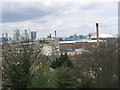
Greenwich Regional Hospital half demolished
As the hospital was dismantled gradually the houses and shops were revealed on Trafalgar Road - and the industry beyond. The horizon is still dominated by Canary and Canada Wharves - and the Dome.
Image: © Rachel Bowles
Taken: 17 Apr 2006
0.06 miles
2
Greenwich Regional Hospital - gone
The last chimney came down with a thunderous bang- and clouds of dust. That was in mid June 2006. The site is still awaiting development, Feb 2007.
Image: © Rachel Bowles
Taken: 18 Jun 2006
0.06 miles
4
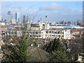
The derelict Greenwich Regional Hospital before demolition
Despite the bulk of the hospital the view is still dominated by Canary Wharf.
Image: © Rachel Bowles
Taken: 28 Mar 2006
0.06 miles
5
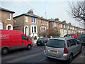
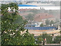
Annandale Road
Houses in East Greenwich built in the 19th Century.
Image: © Dennis Turner
Taken: 5 Feb 2006
0.07 miles
6
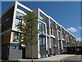
Greenwich Square, block 4
Block 4, consisting of two-storey maisonettes, was among the first part of the site to be occupied.
Image: © Stephen Craven
Taken: 16 May 2015
0.07 miles
7

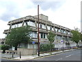
Vanbrugh Health Centre
A NHS clinic on Vanbrugh Hill. See also Image
Image: © Stephen Craven
Taken: 15 Feb 2014
0.08 miles
8
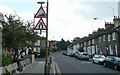
Vanbrugh Hill - Steep Hill 17%
Vanbrugh Hill, Greenwich. 17% steep hill up sign.
Image: © Adam Morse
Taken: 8 Aug 2009
0.08 miles
9
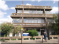
Vanbrugh Health Centre
On the junction of Vanbrugh Hill and Calvert Road.
Image: © David Anstiss
Taken: 11 Sep 2011
0.09 miles
10
Health Clinic, East Greenwich
A health clinic in East Greenwich, in South East London. The building dates from around 1970.
Image: © Malc McDonald
Taken: 23 Jul 2011
0.09 miles