IMAGES TAKEN NEAR TO
Soames Walk, LONDON, SE10 0BN
Introduction
This page details the photographs taken nearby to Soames Walk, SE10 0BN by members of the Geograph project.
The Geograph project started in 2005 with the aim of publishing, organising and preserving representative images for every square kilometre of Great Britain, Ireland and the Isle of Man.

There are currently over 7.5m images from over14,400 individuals and you can help contribute to the project by visiting https://www.geograph.org.uk
Image Map
Images are licensed for reuse under creativecommons.org/licenses/by-sa/2.0
Notes
- Clicking on the map will re-center to the selected point.
- The higher the marker number, the further away the image location is from the centre of the postcode.
Image Listing (605 Images Found)
Images are licensed for reuse under creativecommons.org/licenses/by-sa/2.0
Image
Details
Distance
1
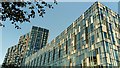
View of flats at 14 Pier Walk from The Tide
The Tide is a new elevated linear park which has been built behind the O2, stretching all the way to the Thames Path. This is the view southwest, showing the flats at 14 Pier Walk.
Image: © Robert Lamb
Taken: 20 Jul 2019
0.01 miles
2
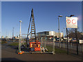
Silvertown Tunnel boreholes (2)
Geotechnical explorations for a proposed road tunnel under the Thames. The project was out for public consultation at the time and attracting strong views both for and against.
Image: © Stephen Craven
Taken: 7 Dec 2014
0.02 miles
3
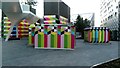
View of a Jubilee line ventilation shaft covered in colourful art
Looking northeast from ground level.
Image: © Robert Lamb
Taken: 20 Jul 2019
0.03 miles
4
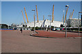
North Greenwich: Unused space
All laid out and surfaced nicely - but what's it for? The buses already have their stands around the tube station. Perhaps it's going to be a coach park.
Behind is seen the O2 arena.
Image: © Dr Neil Clifton
Taken: 13 Jun 2012
0.03 miles
5
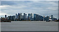
View from Riverside Wharf
North-west towards Canary Wharf's bevy of shiny new towers strutting their stuff. In front, and to the right, are some of the new blocks of flats on Greenwich Peninsula, a bit of the O2 arena, and the cable car (Image]).
Image: © Stephen Richards
Taken: 21 Nov 2020
0.03 miles
6
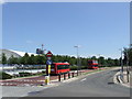
West Parkside and Pilot Busway, North Greenwich
Pilot Busway, to the left, is a two-way bus-only road which runs alongside West Parkside. West Parkside is also two-way. These roads were built in the late 1990s, in preparation for the opening of the Millennium Dome and the London Underground station at North Greenwich.
Image: © Malc McDonald
Taken: 3 Jun 2011
0.04 miles
7
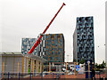
Office on the move
The portable building units comprising the GLLAB (Greenwich Local Labour and Business) offices were being relocated in September 2013 to a new site nearby. Here, part of one unit has just been craned onto a low-loader.
Image: © Stephen Craven
Taken: 10 Sep 2013
0.05 miles
8
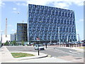
Office blocks at North Greenwich
Recently-built office blocks at North Greenwich. In the background is the O2 entertainment venue, built originally as the Millennium Dome.
Image: © Malc McDonald
Taken: 3 Jun 2011
0.05 miles
9
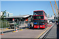
North Greenwich: Bus on Route 472
Plenty of bus routes terminate here outside the tube station. A Stagecoach double-decker pulls out on its way to Thamesmead on Route 472.
Image: © Dr Neil Clifton
Taken: 13 Jun 2012
0.05 miles
10
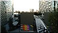
View of a Jubilee line ventilation shaft covered in colourful art from The Tide
The Tide is a new elevated linear park which has been built behind the O2, stretching all the way to the Thames Path. This is the view northwest, showing the Jubilee line ventilation shaft covered in colourful art.
Image: © Robert Lamb
Taken: 20 Jul 2019
0.05 miles