IMAGES TAKEN NEAR TO
Millennium Way, LONDON, SE10 0BF
Introduction
This page details the photographs taken nearby to Millennium Way, SE10 0BF by members of the Geograph project.
The Geograph project started in 2005 with the aim of publishing, organising and preserving representative images for every square kilometre of Great Britain, Ireland and the Isle of Man.

There are currently over 7.5m images from over14,400 individuals and you can help contribute to the project by visiting https://www.geograph.org.uk
Image Map
Images are licensed for reuse under creativecommons.org/licenses/by-sa/2.0
Notes
- Clicking on the map will re-center to the selected point.
- The higher the marker number, the further away the image location is from the centre of the postcode.
Image Listing (154 Images Found)
Images are licensed for reuse under creativecommons.org/licenses/by-sa/2.0
Image
Details
Distance
1
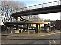
Footbridge approach, SE10
This footbridge over the Blackwall Tunnel southern approach road has a spiral form on the eastern side.
Image: © Peter Thwaite
Taken: 20 Dec 2008
0.01 miles
2
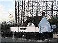
THAT club
An isolated building on the Blackwall Tunnel approach road, formerly a pub called The Mitre, now a nightclub called THAT.
Update: the building (by then called Studio 338) was destroyed by fire on 8 August 2016.
Image: © Stephen Craven
Taken: 7 Nov 2009
0.02 miles
3
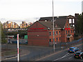
O'Keefe Engineering
The O'Keefe site on the corner of Blackwall Lane and Boord Street, East Greenwich, was formerly occupied by the church of St Andrew and St Michael from 1902 to 1984.
[The church had been listed before demolition but the link I provided to Historic England's listing page no longer works and has not been archived, so I reproduce here the text I wrote for the Diocese of Southwark:
The church seated around 200 people and was allegedly built on a 20ft thick
raft over the marsh. "stock bricks, with pantiled roofs. … A clerestory and
barrel roof: there are no aisle windows. At the west is a narthex, with flying buttresses above: the window is, as usual, large. Two octagonal turrets. The chancel is much raised, with rooms below." (from 'Parish Churches of London', Basil F L Clarke, Batsford, 1966). According to Clarke, it was partly built with the money from the demolition and sale of St Michael's, Wood Street, in the City, which would explain the dual
dedication (there was never a separate St Michael’s at Greenwich).
The Parish was united with Christ Church in 1951 but St Andrew's was not
closed until 1965. An Act of Parliament in 1968 provided for its demolition but the incumbent refused to leave until he died in 1981. It was listed grade B in 1971 and re-listed grade 2 before being demolished some time after 1984.]
Image: © Stephen Craven
Taken: 7 Nov 2009
0.04 miles
4
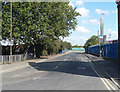
Boord Street
An anonymous little street which may once have been significant but is now a cul-de-sac.
Greenwich Peninsula development in the background.
Image: © Stephen Richards
Taken: 26 Sep 2015
0.04 miles
5
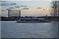
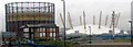
Gas Holder - Speed Ferry and a Sculpture
All seen near the O2 arena in the evening. The clippers are a fast and effective way to travel via the Thames.
Image: © Ashley Dace
Taken: 30 Sep 2010
0.05 miles

8
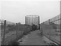
Gas terminal, North Greenwich
The Thames Path abandons the river and heads inland through development sites, not the most scenic of routes.
Image: © Eirian Evans
Taken: 28 Nov 2013
0.05 miles
9
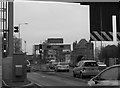
Approach to the Blackwall Tunnel
The gatehouse to the tunnel just right of centre. The tunnel carries northbound traffic only
Image: © Eirian Evans
Taken: 28 Nov 2013
0.05 miles
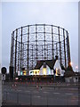
10
Gasometer and various articles of urban clutter near the Blackwall Tunnel
Image: © tristan forward
Taken: 9 Feb 2005
0.05 miles