IMAGES TAKEN NEAR TO
SA99 1ZY
Introduction
This page details the photographs taken nearby to SA99 1ZY by members of the Geograph project.
The Geograph project started in 2005 with the aim of publishing, organising and preserving representative images for every square kilometre of Great Britain, Ireland and the Isle of Man.

There are currently over 7.5m images from over14,400 individuals and you can help contribute to the project by visiting https://www.geograph.org.uk
Image Map
Images are licensed for reuse under creativecommons.org/licenses/by-sa/2.0
Notes
- Clicking on the map will re-center to the selected point.
- The higher the marker number, the further away the image location is from the centre of the postcode.
Image Listing (6 Images Found)
Images are licensed for reuse under creativecommons.org/licenses/by-sa/2.0
Image
Details
Distance
1
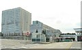
The DVLA at Morriston
Or the "DVLC" in old money. This photo cannot possibly convey how much this place looks like it was designed by Gerry Anderson for use in the original Thunderbirds series. It's from the time that architecture forgot.
Image: © Nigel Davies
Taken: 31 Jul 2005
0.02 miles
2
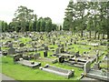
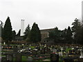
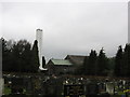
Morriston Cemetery
This is quite a large cemetery. The photo represents only about a quarter of the place. The cemetery is immediately adjacent to the DVLA. There's only 2 certainties in life: Death & Taxes - and they're both right here together in Morriston.
Image: © Nigel Davies
Taken: 31 Jul 2005
0.17 miles
5
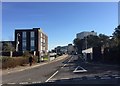
Entrance to the DVLA
Approach road leading to the DVLA, Swansea.
Image: © Alan Hughes
Taken: 14 Feb 2019
0.18 miles
6
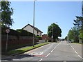
Clasemont Road (A48) west of Morriston
On the right is a pull-off for a bus stop; the corresponding stop on the left is further up the hill; both serve the nearby DVLA offices as well as local housing
Image: © David Smith
Taken: 2 Jun 2018
0.22 miles