IMAGES TAKEN NEAR TO
Ystradowen, SWANSEA, SA9 2YN
Introduction
This page details the photographs taken nearby to SA9 2YN by members of the Geograph project.
The Geograph project started in 2005 with the aim of publishing, organising and preserving representative images for every square kilometre of Great Britain, Ireland and the Isle of Man.

There are currently over 7.5m images from over14,400 individuals and you can help contribute to the project by visiting https://www.geograph.org.uk
Image Map
Images are licensed for reuse under creativecommons.org/licenses/by-sa/2.0
Notes
- Clicking on the map will re-center to the selected point.
- The higher the marker number, the further away the image location is from the centre of the postcode.
Image Listing (18 Images Found)
Images are licensed for reuse under creativecommons.org/licenses/by-sa/2.0
Image
Details
Distance
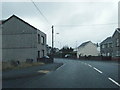
2
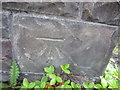
Ordnance Survey Cut Mark
This OS Cut Mark can be found on the south angle of the school in Ystradowen. It marks a point 166.3035m above mean sea level.
Image: © Adrian Dust
Taken: 7 Jul 2013
0.09 miles
3
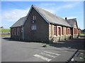
Old School Building, Ystradowen
Now derelict school in Ystradowen.
Image: © Adrian Dust
Taken: 7 Jul 2013
0.09 miles
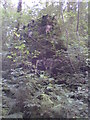
4
Vale Henllys Tramroad
Bryn Henllys Colliery on the Vale Henllys Tramroad (Vale Henllys Walk).
Image: © Tawe Tours
Taken: Unknown
0.11 miles
6
Vale Henllys Tramroad
Bridge column over Vale Henllys Tramroad (Vale Henllys Walk).
Image: © Tawe Tours
Taken: Unknown
0.14 miles
7
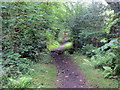
Llwybr i Gwmtwrch Uchaf / Path to Cwmtwrch Uchaf
Llwybr cyhoeddus yn mynd i gyfeiriad pentre Cwmtwrch Uchaf. Mae'r llwybr yn dilyn hen reilffordd a gludai lo o Waith Glo Henllys Vale.
A public footpath heading in the direction of Cwmtwrch Uchaf (trans. upper village of the boar [river] valley). The path follows the former railway which transported coal from Henllys Vale Colliery.
Image: © Alan Richards
Taken: 17 Jul 2020
0.16 miles
8
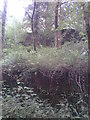
Vale Henllys Tramroad
Bryn Henllys Brickworks on the Vale Henllys Tramroad (Vale Henllys Walk).
Image: © Tawe Tours
Taken: Unknown
0.17 miles
9
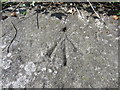
Ordnance Survey Rivet
This OS Rivet of which only the arrow remains, can be found on Bryn-henllys Bridge over the Afon Twrch. It marks a point 143.1371m above mean sea level.
Image: © Adrian Dust
Taken: 7 Jul 2013
0.18 miles
10
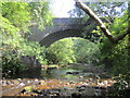
Afon Twrch & Bryn-hennlys Bridge
View of Bridge from the south.
Image: © Adrian Dust
Taken: 7 Jul 2013
0.18 miles