IMAGES TAKEN NEAR TO
Heol Rhyd Ddu Fach, SWANSEA, SA9 2WB
Introduction
This page details the photographs taken nearby to Heol Rhyd Ddu Fach, SA9 2WB by members of the Geograph project.
The Geograph project started in 2005 with the aim of publishing, organising and preserving representative images for every square kilometre of Great Britain, Ireland and the Isle of Man.

There are currently over 7.5m images from over14,400 individuals and you can help contribute to the project by visiting https://www.geograph.org.uk
Image Map (Loading...)


Getting Data...Please wait
Leaflet Map data © OpenStreetMap
Images are licensed for reuse under creativecommons.org/licenses/by-sa/2.0
Notes
- Clicking on the map will re-center to the selected point.
- The higher the marker number, the further away the image location is from the centre of the postcode.
Image Listing (7 Images Found)
Images are licensed for reuse under creativecommons.org/licenses/by-sa/2.0
Image
Details
Distance
1
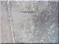
Ordnance Survey Cut Mark
This OS Cut Mark can be found on the south east side of the School. It marks a point 171.8904m above mean sea level.
Image: © Adrian Dust
Taken: 7 Jul 2013
0.06 miles
2
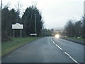
A4068 at the Carmarthenshire county boundary
Image: © Colin Pyle
Taken: 31 Dec 2012
0.10 miles
3
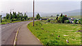
Site of Cwmllynfell station
View northward in the Amman Valley on A4068, with the Carmarthenshire Black Mountains (Carn Ushaf, 1,580 ft.) on the horizon. The station had been over to the right, with the line having been the ex-Midland Swansea (St Thomas) - Ystelyfera - Brynamman (East) line, which was closed to passengers on 25/9/50, to goods on 28/9/64.
Image: © Ben Brooksbank
Taken: 20 May 1990
0.10 miles
4
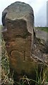
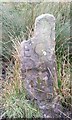
Boundary Stone
Alongside the dismantled Midland Railway. https://www.geograph.org.uk/photo/6755987
Image: © Adrian Dust
Taken: 17 Feb 2021
0.18 miles
5
Boundary Stone
Alongside dismantled Midland Railway
Image: © Adrian Dust
Taken: 17 Feb 2021
0.18 miles
6
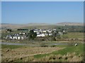
Cefn Bryn Brain
A view of Cefn Bryn Brain village (also within the grid square from where the picture was taken).
Image: © Hywel Williams
Taken: 27 Mar 2002
0.23 miles
7
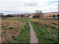
Llwybr i'r A4068 / Path to the A4068
Llwybr cyhoeddus yng Nghefn-bryn-brain arwain at A4068.
A public footpath in Cefn-bryn-brain (trans. hill ridge of crows) heading towards the A4068.
Image: © Alan Richards
Taken: 20 Mar 2020
0.25 miles