IMAGES TAKEN NEAR TO
Lower Pantteg, SWANSEA, SA9 2BY
Introduction
This page details the photographs taken nearby to Lower Pantteg, SA9 2BY by members of the Geograph project.
The Geograph project started in 2005 with the aim of publishing, organising and preserving representative images for every square kilometre of Great Britain, Ireland and the Isle of Man.

There are currently over 7.5m images from over14,400 individuals and you can help contribute to the project by visiting https://www.geograph.org.uk
Image Map
Images are licensed for reuse under creativecommons.org/licenses/by-sa/2.0
Notes
- Clicking on the map will re-center to the selected point.
- The higher the marker number, the further away the image location is from the centre of the postcode.
Image Listing (20 Images Found)
Images are licensed for reuse under creativecommons.org/licenses/by-sa/2.0
Image
Details
Distance
2
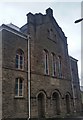
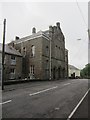
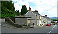
Pant-Teg Independent Chapel
Rebuilt for the final time in 1898, by architect William Williams of Swansea, in the Simple Round-Headed style with a Dutch gable and gable-entry plan.
Image: © Adrian Dust
Taken: 28 Apr 2020
0.03 miles
3
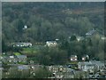
Landslip at Pantteg, Ystalyfera
Just before Christmas 2012 after extended rainfall, the side of the hill above Cyfyng Road at Pantteg, Ystalyfera slipped down and blocked the road. This is a photo of the landslip scar taken from across the valley.
Pantteg Chapel is the large building up on the far right. Left of it and a little higher you can see the exposed earth where the trees and vegetation have slid down.
The land has also slipped further to the left again, under the detached house partially obscured by trees.
The white van that has slid into remaining trees appears to be on the course of a track on the map that may lead up to the detached house.
BBC News story: http://www.bbc.co.uk/news/uk-wales-south-west-wales-20860467
See also Image and Image
Image: © Nigel Davies
Taken: 6 Jan 2013
0.05 miles
4
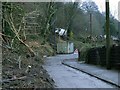
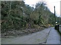
Clearing the landslip from Cyfyng Road
The December landslip in Pantteg completely blocked the road in two places when it first occurred. One lane of mud has already been cleared allowing access for workers to cut up the fallen trees.
See Image for a wider view of the hillside, and Image
Image: © Nigel Davies
Taken: 6 Jan 2013
0.05 miles
5
Landslip on Cyfyng Road
One lane of Cyfyng Road has been cleared but the mud and trees that have slid down are still visible spilling over the retaining wall onto the other lane.
See also Image and Image
Image: © Nigel Davies
Taken: 6 Jan 2013
0.10 miles
6
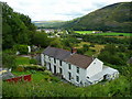
Cottages with a great view
Overlooking the Swansea Valley by Ystalyfera.
Image: © Jonathan Billinger
Taken: 8 Aug 2008
0.13 miles
7
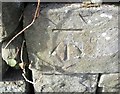
Ordnance Survey Cut Mark
This OS cut mark can be found on the wall on the west side of the road. It marks a point 89.444m above mean sea level.
Image: © Adrian Dust
Taken: 16 Oct 2016
0.13 miles
8
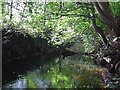
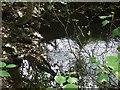
Abandoned waterway
Possibly a section of canal or an industrial water supply fed from the River Tawe it does not appear to be shown on an OS 1:50 map.
Image: © John Phoenix
Taken: 6 Oct 2007
0.13 miles
9
Sluice outfall
Water bubbles up from the closed (but leaky) sluice from the weir on River Tawe into the abandoned waterway.
Image: © John Phoenix
Taken: 6 Oct 2007
0.13 miles
10
Houses on the switchback
Graig Road, left, goes uphill to Ystalyfera, Church Road, right, comes up from the main road which follows the Tawe valley floor.
Image: © Jonathan Billinger
Taken: 8 Aug 2008
0.15 miles