IMAGES TAKEN NEAR TO
Heol Tawe, SWANSEA, SA9 1XP
Introduction
This page details the photographs taken nearby to Heol Tawe, SA9 1XP by members of the Geograph project.
The Geograph project started in 2005 with the aim of publishing, organising and preserving representative images for every square kilometre of Great Britain, Ireland and the Isle of Man.

There are currently over 7.5m images from over14,400 individuals and you can help contribute to the project by visiting https://www.geograph.org.uk
Image Map (Loading...)


Getting Data...Please wait
Leaflet Map data © OpenStreetMap
Images are licensed for reuse under creativecommons.org/licenses/by-sa/2.0
Notes
- Clicking on the map will re-center to the selected point.
- The higher the marker number, the further away the image location is from the centre of the postcode.
Image Listing (43 Images Found)
Images are licensed for reuse under creativecommons.org/licenses/by-sa/2.0
Image
Details
Distance
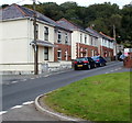
1
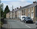
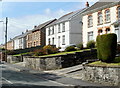
A row of houses, Heol Tawe, Abercrave
Numbers 15 to 29 Heol Tawe are set slightly above road level. Number 29 is nearest the camera. Number 15 is near the School Road junction.
Image: © Jaggery
Taken: 29 Aug 2011
0.04 miles
2
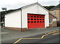
Abercrave Fire Station
Located at the southern end of Maesyfron, viewed across School Road.
The station is part of the Powys Command of the Mid and West Wales Fire and Rescue Service.
The grey training and drill tower http://www.geograph.org.uk/photo/3149499 is in the background.
Image: © Jaggery
Taken: 29 Aug 2011
0.04 miles
3
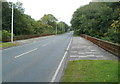
A4067 crosses the River Tawe, Abercrave
A view east along the Abercrave bypass, opened in 1970. http://www.geograph.org.uk/photo/3151330
The metal barriers on each side of the road are part of the bridge across the River Tawe.
Image: © Jaggery
Taken: 29 Aug 2011
0.06 miles
4
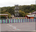
Fire tower and a colourful fence, Abercrave
The training and drill tower in behind the local fire station, http://www.geograph.org.uk/photo/3149509 out of shot on the right.
Viewed from School Road looking across the Abercrave Primary School site.
Image: © Jaggery
Taken: 29 Aug 2011
0.07 miles
5
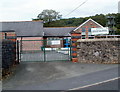
School gates, Abercrave
This is the School Road entrance to Abercrave Primary School.
The grey tower in the right background is part of the nearby fire station. http://www.geograph.org.uk/photo/3149509
Image: © Jaggery
Taken: 29 Aug 2011
0.07 miles
6
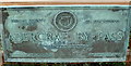
Plaque recording the opening in 1970 of the Abercrave bypass
The Brecon County Council plaque is on the side of the bridge http://www.geograph.org.uk/photo/3151313
carrying the A4067 across the River Tawe. Abercraf is the Welsh name of the village.
Image: © Jaggery
Taken: 29 Aug 2011
0.07 miles
7
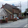
Abercrave Post Office
A squat red postbox on a black stand is outside the village post office at 14 Heol Tawe.
Image: © Jaggery
Taken: 29 Aug 2011
0.07 miles
8
Heol Tawe houses west of the former Bryn Seion chapel, Abercrave
The houses are on the north side of the road, viewed from opposite a former chapel. http://www.geograph.org.uk/photo/3149423
Image: © Jaggery
Taken: 29 Aug 2011
0.08 miles
9
School Road houses, Abercrave
The houses are at the northern end of School Road, on the approach to Tanyrallt. http://www.geograph.org.uk/photo/3149523
Image: © Jaggery
Taken: 29 Aug 2011
0.09 miles
10
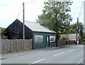
Disused corrugated building, Heol Tawe, Abercrave
Located on the south side of Heol Tawe between School Road and Hennoyadd Road.
The corrugated sheet metal covering the windows suggests that the building is disused. Alan Jones has informed me that "this was once a shop that sold bread"
Image: © Jaggery
Taken: 29 Aug 2011
0.09 miles