IMAGES TAKEN NEAR TO
Brooklands Terrace, SWANSEA, SA9 1UF
Introduction
This page details the photographs taken nearby to Brooklands Terrace, SA9 1UF by members of the Geograph project.
The Geograph project started in 2005 with the aim of publishing, organising and preserving representative images for every square kilometre of Great Britain, Ireland and the Isle of Man.

There are currently over 7.5m images from over14,400 individuals and you can help contribute to the project by visiting https://www.geograph.org.uk
Image Map (Loading...)


Getting Data...Please wait
Leaflet Map data © OpenStreetMap
Images are licensed for reuse under creativecommons.org/licenses/by-sa/2.0
Notes
- Clicking on the map will re-center to the selected point.
- The higher the marker number, the further away the image location is from the centre of the postcode.
Image Listing (12 Images Found)
Images are licensed for reuse under creativecommons.org/licenses/by-sa/2.0
Image
Details
Distance
1
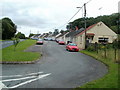
Brooklands Terrace, Caehopkin
Brooklands Terrace is a row of 20 semi-detached bungalows on the south side of the A4221 between Abercrave and Coelbren.
Image: © Jaggery
Taken: 29 Aug 2011
0.04 miles
2
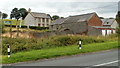
Tyn y Pant farm buildings, Caehopkin
Viewed from the edge of Brooklands Terrace. http://www.geograph.org.uk/photo/3152006
Image: © Jaggery
Taken: 29 Aug 2011
0.08 miles
3
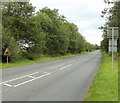
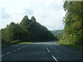
Sheep country between Abercrave and Coelbren
A triangular sign on the left warns of the possibility of sheep on the A4221 on the long ascent from Abercrave to Coelbren.
Image: © Jaggery
Taken: 29 Aug 2011
0.10 miles
4
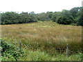
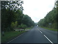
A view south from the A4221 near Caehopkin
Taken in late August from the road from Abercrave to Coelbren.
Image: © Jaggery
Taken: 29 Aug 2011
0.11 miles
7
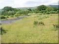
NCN 43 at Caehopkin
The newly opened cycleway weaves around the site of the long-gone purification works next to the International Anthracite Colliery & whilst to its south (behind the photographer) are the grassed mounds of the huge Nant Helen opencast site. The skyline is formed by the limestone mini-mountain of Cribarth.
Image: © Alan Bowring
Taken: 29 Jun 2009
0.21 miles
8
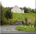
Scout building, Caehopkin
A sign on the A4221 http://www.geograph.org.uk/photo/3152062 shows "Scout Hut" but this building isn't exactly a hut! The name sign shows
1st CAEHOPKIN "PINE" SCOUT GROUP
PACK HOLIDAY CENTRE
DONATED BY THE CHAIRMAN OF TAWE UCHAF COMMUNITY COUNCIL D.MURROW 1998/99.
Image: © Jaggery
Taken: 29 Aug 2011
0.23 miles
9
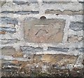
Ordnance Survey Cut Mark
This OS cut mark can be found on the wall of Pen-y-Bryn. It marks a point 180.686m above mean sea level.
Image: © Adrian Dust
Taken: 10 Jul 2020
0.23 miles
10
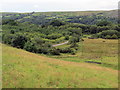
Llethr ger Caehopkin / Hillside near Caehopkin
Edrych i lawr ar lwybr beicio ger Caehopkin.
Looking down on a cycle path near Caehopkin (trans. Hopkin's field).
Image: © Alan Richards
Taken: 29 Jul 2020
0.23 miles