IMAGES TAKEN NEAR TO
Vicarage Drive, SWANSEA, SA8 4PB
Introduction
This page details the photographs taken nearby to Vicarage Drive, SA8 4PB by members of the Geograph project.
The Geograph project started in 2005 with the aim of publishing, organising and preserving representative images for every square kilometre of Great Britain, Ireland and the Isle of Man.

There are currently over 7.5m images from over14,400 individuals and you can help contribute to the project by visiting https://www.geograph.org.uk
Image Map (Loading...)


Getting Data...Please wait
Leaflet Map data © OpenStreetMap
Images are licensed for reuse under creativecommons.org/licenses/by-sa/2.0
Notes
- Clicking on the map will re-center to the selected point.
- The higher the marker number, the further away the image location is from the centre of the postcode.
Image Listing (42 Images Found)
Images are licensed for reuse under creativecommons.org/licenses/by-sa/2.0
Image
Details
Distance
1
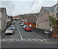
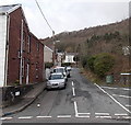
Heathfield Road, Pontardawe
Heathfield Road climbs away from Brecon Road towards Oakfield Road and Upper Heathfield Road.
Image: © Jaggery
Taken: 1 Mar 2014
0.06 miles
2
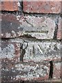
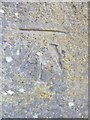
Ordnance Survey Cut Mark
This damaged OS Cut Mark can be found on a garage at the top of Coedcae Road. It marks a point 80.6166m above mean sea level.
Image: © Adrian Dust
Taken: 13 Jul 2013
0.07 miles
3
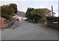
Oakfield Road, Pontardawe
Viewed from the corner of Smithfield Road.
Image: © Jaggery
Taken: 1 Mar 2014
0.08 miles
4
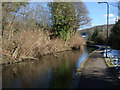
The Swansea Canal at Pontardawe
Looking east
Image: © Kevin Flynn
Taken: 3 Mar 2006
0.09 miles
5
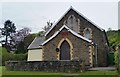
Mount Elim Baptist Chapel
Built in 1886 in the Simple Gothic style.
Image: © Adrian Dust
Taken: 3 May 2020
0.09 miles
6
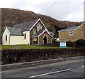
Mount Elim Evangelical Church, Ynysmeudwy near Pontardawe
Viewed across Brecon Road. The church is located a few metres on the Ynysmeudwy side http://www.geograph.org.uk/photo/3994881 of the Pontardawe boundary.
Image: © Jaggery
Taken: 1 Mar 2014
0.09 miles
7
Ordnance Survey Cut Mark
This OS Cut Mark can be found on the right stone gate post of a driveway on the NW side of Brecon Road. It marks a point 49.9567m above mean sea level.
Image: © Adrian Dust
Taken: 13 Jul 2013
0.09 miles
8
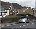
Ynysmeudwy boundary sign
Brecon Road from Pontardawe passes the Ynysmeudwy boundary sign
on the perimeter wall of Mount Elim Evangelical Church. http://www.geograph.org.uk/photo/3994871
Image: © Jaggery
Taken: 1 Mar 2014
0.10 miles
9
Coedcae, Ynysmeudwy
Viewed across Brecon Road. This is the SE end of an area of houses extending for about 250 metres in the street named Coedcae.
Image: © Jaggery
Taken: 1 Mar 2014
0.10 miles
10
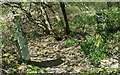
Old stone gateposts
In woodland above Pontardawe.
Image: © Adrian Dust
Taken: 14 Apr 2020
0.10 miles