IMAGES TAKEN NEAR TO
Godre'r Fro, SWANSEA, SA8 4NG
Introduction
This page details the photographs taken nearby to Godre'r Fro, SA8 4NG by members of the Geograph project.
The Geograph project started in 2005 with the aim of publishing, organising and preserving representative images for every square kilometre of Great Britain, Ireland and the Isle of Man.

There are currently over 7.5m images from over14,400 individuals and you can help contribute to the project by visiting https://www.geograph.org.uk
Image Map (Loading...)


Getting Data...Please wait
Leaflet Map data © OpenStreetMap
Images are licensed for reuse under creativecommons.org/licenses/by-sa/2.0
Notes
- Clicking on the map will re-center to the selected point.
- The higher the marker number, the further away the image location is from the centre of the postcode.
Image Listing (6 Images Found)
Images are licensed for reuse under creativecommons.org/licenses/by-sa/2.0
Image
Details
Distance
1
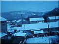
Alltycham
This is the view from my house in Pontardawe during the snowy days of November 2005.
Image: © Aaron Jones
Taken: 25 Nov 2005
0.10 miles
3
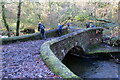
Pont ger Melin Gelligron / Bridge at Gelligron Mill
Pont yn rhychwantu Afon Clydach Uchaf. Safai Melin Gelligron ar y lan gyferbyn a hynny o bosibl sy'n gyfrif am fodolaeth y bont faen gadarn hon.
A bridge spanning the Upper Clydach River. Gelligron Corn Mill stood on the opposite bank and this may account for the substantial stone structure.
Image: © Alan Richards
Taken: 6 Dec 2020
0.21 miles
4
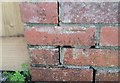
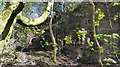
Ordnance Survey Cut Mark
This OS pivot can be found on No26 Cefnllan Road. It marks a point 110.722m above mean sea level.
Image: © Adrian Dust
Taken: 14 Apr 2020
0.23 miles
5
Ordnance Survey Rivet
This OS rivet can be found on the wall of No40 Gelligron Road. It marks a point 99.703m above mean sea level.
Image: © Adrian Dust
Taken: 14 Apr 2020
0.24 miles