IMAGES TAKEN NEAR TO
Hopkin Street, SWANSEA, SA8 4JQ
Introduction
This page details the photographs taken nearby to Hopkin Street, SA8 4JQ by members of the Geograph project.
The Geograph project started in 2005 with the aim of publishing, organising and preserving representative images for every square kilometre of Great Britain, Ireland and the Isle of Man.

There are currently over 7.5m images from over14,400 individuals and you can help contribute to the project by visiting https://www.geograph.org.uk
Image Map
Images are licensed for reuse under creativecommons.org/licenses/by-sa/2.0
Notes
- Clicking on the map will re-center to the selected point.
- The higher the marker number, the further away the image location is from the centre of the postcode.
Image Listing (131 Images Found)
Images are licensed for reuse under creativecommons.org/licenses/by-sa/2.0
Image
Details
Distance
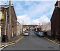
1
Quarr Road, Pontardawe
Looking NNE along Quarr Road from Dynevor Terrace. Quarr is not a typo for Quarry.
Image: © Jaggery
Taken: 1 Mar 2014
0.02 miles
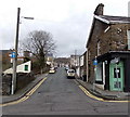
2
Quarr Road, Pontardawe
Viewed from Church Street looking NNE along Quarr Road towards Hopkin Street.
Quarr is not a typo for Quarry. Rainbow House http://www.geograph.org.uk/photo/3918483 is on the left.
Image: © Jaggery
Taken: 1 Mar 2014
0.02 miles
3
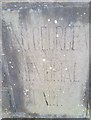
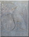
Stone Plaque
This Stone Plaque can be found on the gatepost at the entrance to the King George V Memorial Park.
Image: © Adrian Dust
Taken: 13 Apr 2020
0.04 miles
4
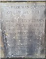
Commemorative Stone Plaque
This Stone Plaque can be found on the gatepost at the entrance to the King George V Memorial Park.
Image: © Adrian Dust
Taken: 13 Apr 2020
0.04 miles
5
Stone Plaque
This Stone Plaque can be found on the gatepost at the entrance to the King George V Memorial Park.
Image: © Adrian Dust
Taken: 13 Apr 2020
0.04 miles
6
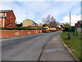
Allt-y-cham Drive, Pontardawe
This part of Allt-y-cham Drive is between Ffordd Bryneulog and Hopkin Street.
The lorry is part of the Nolan Transport fleet.
Image: © Jaggery
Taken: 1 Mar 2014
0.05 miles
8
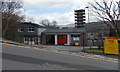
Pontardawe Fire Station
Viewed across Allt-y-cham Drive. Pontardawe Fire Station is part of the Neath Port Talbot County Command of the Mid and West Wales Fire and Rescue Service. The building dates from the late 1960s.
Image: © Jaggery
Taken: 1 Mar 2014
0.07 miles
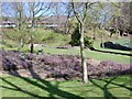
9

Pontardawe Swimming Pool
Viewed from the SW corner of the pool site located in King George V Park, accessed from Jones Street.
Image: © Jaggery
Taken: 1 Mar 2014
0.09 miles
10
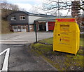
Yellow charity bin outside Pontardawe Fire Station
Located at the entrance to the station, http://www.geograph.org.uk/photo/3873920 the bin is for donations to The Fire Fighters Charity.
Image: © Jaggery
Taken: 1 Mar 2014
0.09 miles