IMAGES TAKEN NEAR TO
Herbert Street, SWANSEA, SA8 4ED
Introduction
This page details the photographs taken nearby to Herbert Street, SA8 4ED by members of the Geograph project.
The Geograph project started in 2005 with the aim of publishing, organising and preserving representative images for every square kilometre of Great Britain, Ireland and the Isle of Man.

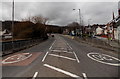
There are currently over 7.5m images from over14,400 individuals and you can help contribute to the project by visiting https://www.geograph.org.uk
Image Map
Images are licensed for reuse under creativecommons.org/licenses/by-sa/2.0
Notes
- Clicking on the map will re-center to the selected point.
- The higher the marker number, the further away the image location is from the centre of the postcode.
Image Listing (179 Images Found)
Images are licensed for reuse under creativecommons.org/licenses/by-sa/2.0
Image
Details
Distance
1
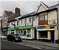
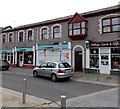
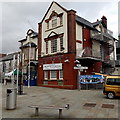
Charlo's Fish & Chips, Pontardawe
Viewed across Herbert Street in the town centre. Also in view are The Co-operative Food Store and Greggs.
Image: © Jaggery
Taken: 1 Mar 2014
0.01 miles
2
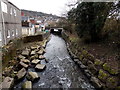
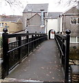
Downstream along the Upper Clydach River, Pontardawe
Viewed from this http://www.geograph.org.uk/photo/3998921 footbridge looking towards the A474 bridge.
The Upper Clydach flows into the Tawe about 300 metres ahead.
Image: © Jaggery
Taken: 1 Mar 2014
0.02 miles
3
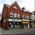
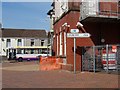
Lloyds Pharmacy, Pontardawe
The Herbert Street pharmacy is next door to Jenkins bakery. Lloyds Bank http://www.geograph.org.uk/photo/3867692 is on the right.
Image: © Jaggery
Taken: 1 Mar 2014
0.02 miles
4
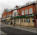
Lloyds Bank, Pontardawe
The town centre bank branch at 66 Herbert Street was formerly a branch of Lloyds TSB, rebranded in September 2013.
Image: © Jaggery
Taken: 1 Mar 2014
0.02 miles
5
WNW along the A474 in Pontardawe
This part of the A474 is alongside Herbert Street.
Image: © Jaggery
Taken: 1 Mar 2014
0.02 miles
6
Village Cards & Gifts and The Co-operative Pharmacy, Pontardawe
Viewed across Herbert Street.
Image: © Jaggery
Taken: 1 Mar 2014
0.03 miles
7
Upper Clydach River footbridge, Pontardawe
Viewed from the A474 side looking towards Herbert Street.
Image: © Jaggery
Taken: 1 Mar 2014
0.04 miles
8
Poteau indicateur ? Pontardawe
This French signpost outside the Arts Centre in Herbert Street points the way to Pontardawe's twin town, Locminé in Brittany (via Brecon? -- although periodically adjusted by vandals the signpost is usually turned this way). The indicated distance of 765 km seems a little exaggerated, though, as the route (via Plymouth and Roscoff) totals about 650 km according to Michelin.
Image: © Kevin Flynn
Taken: 4 Apr 2007
0.04 miles
9
Herbert Street side of Pontardawe Arts Centre
A French-style sign pointing right shows LOCMINE 765.
Pontardawe is twinned with Locminé in Brittany.
Image: © Jaggery
Taken: 1 Mar 2014
0.04 miles
10
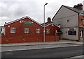
Pontardawe Jubilee Club
The club at 98 Herbert Street is home to the Pontardawe branch of the Royal British Legion.
Image: © Jaggery
Taken: 1 Mar 2014
0.04 miles