IMAGES TAKEN NEAR TO
Little Castle Grove, MILFORD HAVEN, SA73 3SP
Introduction
This page details the photographs taken nearby to Little Castle Grove, SA73 3SP by members of the Geograph project.
The Geograph project started in 2005 with the aim of publishing, organising and preserving representative images for every square kilometre of Great Britain, Ireland and the Isle of Man.

There are currently over 7.5m images from over14,400 individuals and you can help contribute to the project by visiting https://www.geograph.org.uk
Image Map
Images are licensed for reuse under creativecommons.org/licenses/by-sa/2.0
Notes
- Clicking on the map will re-center to the selected point.
- The higher the marker number, the further away the image location is from the centre of the postcode.
Image Listing (18 Images Found)
Images are licensed for reuse under creativecommons.org/licenses/by-sa/2.0
Image
Details
Distance
1
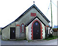
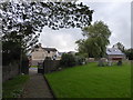
Church Hall
St.Mary's Church Hall built 1912 in the village of Herbrandston.
Image: © Dara Jasumani
Taken: 27 Apr 2006
0.03 miles
4
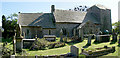
St Mary's Church, Herbrandston
Medieval parish church in Herbrandston, listed Grade II
Image: © Eirian Evans
Taken: 30 Aug 2022
0.12 miles
5
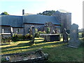
St Mary's Church, Herbrandston
Medieval parish church in Herbrandston, listed Grade II
Image: © Eirian Evans
Taken: 30 Aug 2022
0.12 miles
6
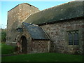
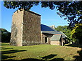
St. Mary's church, Herbrandston
This church has a rather unusual tower, which has a tiled roof. Records of christenings and burials can be traced back to 1717 (Pembrokeshire Records Office), although the current building was built largely by the local residents of Hakin in 1927.
Image: © Robin Lucas
Taken: 24 Oct 2008
0.13 miles
7
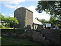
St Mary's Church
There is an Ordnance Survey Cut Mark on the porch. http://www.geograph.org.uk/photo/4013671
Image: © Adrian Dust
Taken: 5 Jun 2014
0.13 miles
8
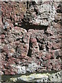
Ordnance Survey Cut Mark
This OS cut mark can be found on the porch of St Mary's Church. It marks a point 53.438m above mean sea level. http://www.geograph.org.uk/photo/4013665
Image: © Adrian Dust
Taken: 5 Jun 2014
0.13 miles
10
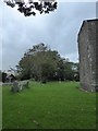
St. Mary, Herbrandston: churchyard (c)
Image: © Basher Eyre
Taken: 29 Aug 2019
0.13 miles