IMAGES TAKEN NEAR TO
Gelliswick Road, MILFORD HAVEN, SA73 3RB
Introduction
This page details the photographs taken nearby to Gelliswick Road, SA73 3RB by members of the Geograph project.
The Geograph project started in 2005 with the aim of publishing, organising and preserving representative images for every square kilometre of Great Britain, Ireland and the Isle of Man.

There are currently over 7.5m images from over14,400 individuals and you can help contribute to the project by visiting https://www.geograph.org.uk
Image Map (Loading...)


Getting Data...Please wait
Leaflet Map data © OpenStreetMap
Images are licensed for reuse under creativecommons.org/licenses/by-sa/2.0
Notes
- Clicking on the map will re-center to the selected point.
- The higher the marker number, the further away the image location is from the centre of the postcode.
Image Listing (70 Images Found)
Images are licensed for reuse under creativecommons.org/licenses/by-sa/2.0
Image
Details
Distance
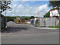
2
Hubberston
View to the church from the lane to Liddeston.
Image: © Deborah Tilley
Taken: 20 Dec 2008
0.06 miles
3
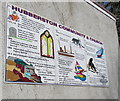
Hubberston Community & Church information
On a wall near the entrance to St David's churchyard. Vikings landed at nearby Gelliswick Bay in 800 A.D. Hubberston takes its name from Hubba, the Viking chief who founded the settlement of Hubberston.
Image: © Jaggery
Taken: 11 Mar 2019
0.08 miles
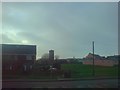
4

CK Foodstores Hakin Nisa Local, Milford Haven
The Gelliswick Road convenience store is in a short row of shops opposite Croft Avenue in the Hakin area of Milford Haven.
Image: © Jaggery
Taken: 31 Aug 2012
0.08 miles
5
Deano's Pizza, Gelliswick Road, Hakin, Milford Haven
Pizza takeaway next door to CK Foodstores. https://www.geograph.org.uk/photo/6086092
Image: © Jaggery
Taken: 11 Mar 2019
0.08 miles
6
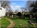
Path in St David's churchyard, Hubberston
In the churchyard on the south side of this https://www.geograph.org.uk/photo/6333492 church
Image: © Jaggery
Taken: 11 Mar 2019
0.08 miles
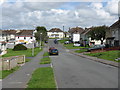
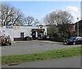
9
Hubberston Green, Milford Haven
In view are St David's Church http://www.geograph.org.uk/photo/3111598 and Hubberston Youth Centre. http://www.geograph.org.uk/photo/3111695
The village of Hubberston, now part of Milford Haven, was built around the church.
Image: © Jaggery
Taken: 31 Aug 2012
0.09 miles
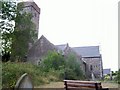
10
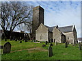
St David's Church, Hubberston
In the Church in Wales Diocese of St Davids. The village of Hubberston, now part of Milford Haven, was built around this church, which one source states dates from the 13th century, whereas another source has 15th century, possibly with an earlier core. The building was Grade I listed in 1951.
Image: © Jaggery
Taken: 11 Mar 2019
0.09 miles