IMAGES TAKEN NEAR TO
Picton Close, MILFORD HAVEN, SA73 3EL
Introduction
This page details the photographs taken nearby to Picton Close, SA73 3EL by members of the Geograph project.
The Geograph project started in 2005 with the aim of publishing, organising and preserving representative images for every square kilometre of Great Britain, Ireland and the Isle of Man.

There are currently over 7.5m images from over14,400 individuals and you can help contribute to the project by visiting https://www.geograph.org.uk
Image Map (Loading...)


Getting Data...Please wait
Leaflet Map data © OpenStreetMap
Images are licensed for reuse under creativecommons.org/licenses/by-sa/2.0
Notes
- Clicking on the map will re-center to the selected point.
- The higher the marker number, the further away the image location is from the centre of the postcode.
Image Listing (28 Images Found)
Images are licensed for reuse under creativecommons.org/licenses/by-sa/2.0
Image
Details
Distance
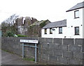
2
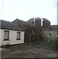
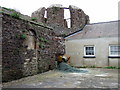
Charles Francis Greville's observatory (See Ceridwen's informative notes)
Sadly, in the same (probably worse) condition as is 2007 when Ceridwen took her photographs. Astonishing to see a Grade 1 listed building treated in this way.
Image: © Deborah Tilley
Taken: 14 Feb 2009
0.07 miles
3
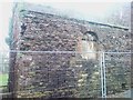
Hakin observatory
This surprising structure can be found nestled cheek by jowl with the modern housing and back-yard clutter that has accumulated around it since it was built by Charles Francis Greville (1749-1809) in the early years of the C19 as part of a planned mathematics, engineering and technical college. Thomas Firminger (1775-1861), previously Assistant to Nevil Maskelyne at Greenwich, was appointed briefly as superintendent. An excellent collection of instruments was assembled, including the celebrated Lee transit circle. The plans were abandoned after Greville's death due to a lack of money and interest and although the observatory was completed, the college itself never came into being.
Image: © Natasha Ceridwen de Chroustchoff
Taken: 17 Mar 2007
0.08 miles
5
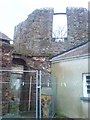
Hakin observatory back view
Squatting amongst casual modern surroundings the observatory has a slightly sinister appearance, like a wartime relic, but in fact its purpose was simply to train naval students in navigation at a time, a decade or so into the C19, when the problem of longitude had not yet been solved and an accurate knowledge the stars was essential for sailors.
Image: © Natasha Ceridwen de Chroustchoff
Taken: 17 Mar 2007
0.08 miles
8
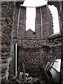
Hakin observatory interior
The observatory consisted of an octagonal two-storey tower with a conical roof and vertical side-slits. The roof and internal structure have fallen in and steel struts have been used to brace the walls. Although it is protected as an ancient monument there is no sign of any attempt to restore this fascinating building (Griff Rees Jones, where are you?).
Image: © Natasha Ceridwen de Chroustchoff
Taken: 17 Mar 2007
0.09 miles
9
What on earth is it?
The streetname gives the game away but there is nothing on the OS map, nor in the Pevsner Architectural Guide, to prepare you for this sight of an early C19 observatory lurking in the middle of a C20 housing estate here in the Milford Haven suburb of Hakin. Although in private ownership it is a Grade One monument.
Image: © Natasha Ceridwen de Chroustchoff
Taken: 17 Mar 2007
0.10 miles
10

The aptly named Observatory Hall
A public house.
Image: © Deborah Tilley
Taken: 14 Feb 2009
0.10 miles