IMAGES TAKEN NEAR TO
Milton Crescent, MILFORD HAVEN, SA73 2QP
Introduction
This page details the photographs taken nearby to Milton Crescent, SA73 2QP by members of the Geograph project.
The Geograph project started in 2005 with the aim of publishing, organising and preserving representative images for every square kilometre of Great Britain, Ireland and the Isle of Man.

There are currently over 7.5m images from over14,400 individuals and you can help contribute to the project by visiting https://www.geograph.org.uk
Image Map
Images are licensed for reuse under creativecommons.org/licenses/by-sa/2.0
Notes
- Clicking on the map will re-center to the selected point.
- The higher the marker number, the further away the image location is from the centre of the postcode.
Image Listing (44 Images Found)
Images are licensed for reuse under creativecommons.org/licenses/by-sa/2.0
Image
Details
Distance
1
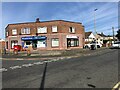
Pill Corner Store
At the junction of Pill Lane and Murray Road
Image: © Eirian Evans
Taken: 31 Aug 2022
0.08 miles
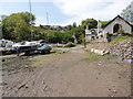
2
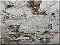
Ordnance Survey Cut Mark
This OS cut mark can be found on the garage south side of Cellar Hill. It marks a point 6.639m above mean sea level.
Image: © Adrian Dust
Taken: 28 Mar 2022
0.09 miles
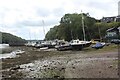
3
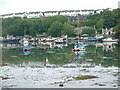
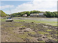
Castle Pill
Low tide at Castle Pill reveals a shallow muddy estuary. This view is from the eastern end of Black Bridge.
Image: © Robin Lucas
Taken: 15 May 2009
0.09 miles
4
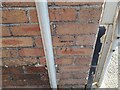
Ordnance Survey Cut Mark
This OS cut mark can be found on No63 Pill Lane. It marks a point 34.156m above mean sea level.
Image: © Adrian Dust
Taken: 28 Mar 2022
0.09 miles
5
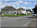
Milford Haven - Semis On Pill Road
Coombs Drive goes off to the left.
Image: © Peter Whatley
Taken: 23 Jul 2009
0.10 miles
6
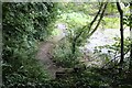
The Pembrokeshire Coast Path near Pill
Low water route.
Image: © Dave Kelly
Taken: 9 May 2017
0.10 miles
7
Boats on bank of Castle Pill, Cellar Hill
Boats beached on the right bank of the tidal river.
Image: © M J Roscoe
Taken: 24 Aug 2023
0.11 miles
9
The Pembrokeshire Coast Path near Pill
Low water route.
Image: © Dave Kelly
Taken: 9 May 2017
0.11 miles
10
Looking down the Coast Path by Castle Pill
There are steps up from the riverside path visible in the picture to the camera position.
Image: © M J Roscoe
Taken: 24 Aug 2023
0.13 miles