IMAGES TAKEN NEAR TO
College Park, MILFORD HAVEN, SA73 1TY
Introduction
This page details the photographs taken nearby to College Park, SA73 1TY by members of the Geograph project.
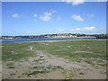
The Geograph project started in 2005 with the aim of publishing, organising and preserving representative images for every square kilometre of Great Britain, Ireland and the Isle of Man.

There are currently over 7.5m images from over14,400 individuals and you can help contribute to the project by visiting https://www.geograph.org.uk
Image Map (Loading...)


Getting Data...Please wait
Leaflet Map data © OpenStreetMap
Images are licensed for reuse under creativecommons.org/licenses/by-sa/2.0
Notes
- Clicking on the map will re-center to the selected point.
- The higher the marker number, the further away the image location is from the centre of the postcode.
Image Listing (56 Images Found)
Images are licensed for reuse under creativecommons.org/licenses/by-sa/2.0
Image
Details
Distance
1
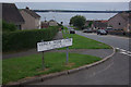
Riverside Avenue, Neyland
Looking down Riverside Avenue from its junction with Sidney Webb Close. The area enjoys a panoramic view of the Cleddau Estuary.
Image: © Stephen McKay
Taken: 22 Aug 2010
0.10 miles
3
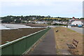
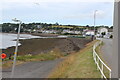
Riverside path alongside road
The path, part of the Coast Path, sits on a stone wall Image overlooking a mud and shingle beach. Llanstadwell is in the background.
Image: © M J Roscoe
Taken: 4 Jul 2023
0.12 miles
4
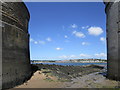
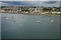
Neyland seen from Pembroke Dock
View taken between the dockyard wall and the North East Gun Tower.
Image: © Jonathan Thacker
Taken: 14 Jun 2018
0.12 miles
5
Mudflats and Neyland
Neyland was once the main transfer point for traffic between South Wales and Ireland but lost this role initially to Fishguard and now to a large extent Pembroke Dock.
Image: © Jonathan Thacker
Taken: 14 Jun 2018
0.12 miles
6
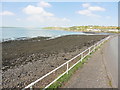
Shore below Trafalgar Terrace, B4325
The foreshore on a receding tide looking towards Llanstadwell.
Image: © M J Roscoe
Taken: 4 Jul 2023
0.12 miles
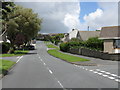
8
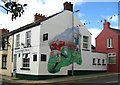
Gunning's Bar, St Clements Road, Neyland
Image: © Shaun Butler
Taken: 13 Aug 2008
0.13 miles
9
Neyland, Milford Haven
Neyland is situated on the north shore of Milford Sound, opposite Pembroke Dock. Viewed here from the Pembroke to Rosslare ferry.
Image: © Philip Halling
Taken: 24 Jun 2007
0.13 miles
10
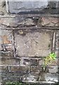
Ordnance Survey Cut Mark
This OS cut mark can be found on the wall of the Methodist Church, High Street. It marks a point 39.716m above mean sea level.
Image: © Adrian Dust
Taken: 18 Mar 2020
0.14 miles