IMAGES TAKEN NEAR TO
Bush Street, PEMBROKE DOCK, SA72 6XB
Introduction
This page details the photographs taken nearby to Bush Street, SA72 6XB by members of the Geograph project.
The Geograph project started in 2005 with the aim of publishing, organising and preserving representative images for every square kilometre of Great Britain, Ireland and the Isle of Man.

There are currently over 7.5m images from over14,400 individuals and you can help contribute to the project by visiting https://www.geograph.org.uk
Image Map
Images are licensed for reuse under creativecommons.org/licenses/by-sa/2.0
Notes
- Clicking on the map will re-center to the selected point.
- The higher the marker number, the further away the image location is from the centre of the postcode.
Image Listing (157 Images Found)
Images are licensed for reuse under creativecommons.org/licenses/by-sa/2.0
Image
Details
Distance
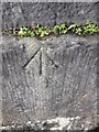
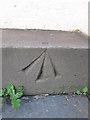
1
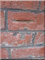
Ordnance Survey Cut Mark
This OS cut mark can be found on the Charlton PH, No20 Bush Street. It marks a point 17.883m above mean sea level.
Image: © Adrian Dust
Taken: 31 Oct 2015
0.03 miles
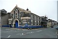
2
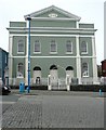
Zion Free Church, Meyrick Street
Built as the Tabernacle Wesleyan Chapel 1846-8. "It was known was closed and put on the market in 1986, when it was purchased and renamed 'Zion Free Church'. ... Prior to the chapel's purchase the basement of the chapel was used as the Town's Library until it was claimed that the building was unsafe for public use.The building was bought by Mr Hugh Michael who despite the sorry and deteriorating aspects of the building, with his own hands and the help of volunteers the church has been restored to its former resplendence." (From http://www.thedock.org.uk/page_28.htm) For a view of the interior see http://www.capeli.org.uk/llun.php?src=pembroke_dock_058.jpg&teitl=Interior+Zion+Free+Church&testun=Interior+of+Zion+Free+Church%2C+Pembroke+Dock
Image: © Humphrey Bolton
Taken: 31 Mar 2011
0.05 miles
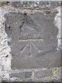
3
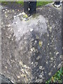
Ordnance Survey Pivot
This OS pivot can be found on the angle of the school wall. It marks a point 19.787m above mean sea level.
Image: © Adrian Dust
Taken: 31 Oct 2015
0.06 miles
4
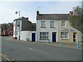
Pembroke Dock Spiritualist Church, Queen Street
Image: © Humphrey Bolton
Taken: 31 Mar 2011
0.07 miles
5
Bethel Baptist Chapel, Meyrick Street, Pembroke Dock
Dated 1845, but The Buildings of Wales - Pembrokeshire' states that it was built in 1873-5.
Image: © Humphrey Bolton
Taken: 31 Mar 2011
0.07 miles
6
Ordnance Survey Pivot
This OS pivot can be found on the gatepost to the Burial Ground. It marks a point 22.467m above mean sea level.
Image: © Adrian Dust
Taken: 31 Oct 2015
0.08 miles
7
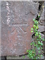
Ordnance Survey Cut Mark
This OS cut mark can be found on the north facing school wall. It marks a point 19.065m above mean sea level.
Image: © Adrian Dust
Taken: 31 Oct 2015
0.08 miles
8
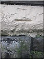
Ordnance Survey Cut Mark
This OS cut mark can be found on the north face of the Bethel Baptist Chapel. It marks a point 15.347m above mean sea level.
Image: © Adrian Dust
Taken: 31 Oct 2015
0.08 miles
9
Ordnance Survey Pivot
This OS pivot can be found on the step of the Bethel Baptist Chapel. It marks a point 16.171m above mean sea level.
Image: © Adrian Dust
Taken: 31 Oct 2015
0.09 miles
10
Ordnance Survey Cut Mark
This OS cut mark can be found on the east facing wall, Charlton Place. It marks a point 24.137m above mean sea level.
Image: © Adrian Dust
Taken: 31 Oct 2015
0.09 miles