IMAGES TAKEN NEAR TO
Grove Street, PEMBROKE DOCK, SA72 6RE
Introduction
This page details the photographs taken nearby to Grove Street, SA72 6RE by members of the Geograph project.
The Geograph project started in 2005 with the aim of publishing, organising and preserving representative images for every square kilometre of Great Britain, Ireland and the Isle of Man.

There are currently over 7.5m images from over14,400 individuals and you can help contribute to the project by visiting https://www.geograph.org.uk
Image Map
Images are licensed for reuse under creativecommons.org/licenses/by-sa/2.0
Notes
- Clicking on the map will re-center to the selected point.
- The higher the marker number, the further away the image location is from the centre of the postcode.
Image Listing (12 Images Found)
Images are licensed for reuse under creativecommons.org/licenses/by-sa/2.0
Image
Details
Distance
1
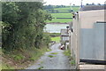
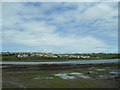
Lane, Lower Pennar
The unnamed lane goes down towards the Pembroke River (at low tide here) to Fleet Street.
Image: © M J Roscoe
Taken: 1 Aug 2023
0.07 miles
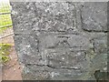
2
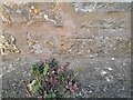
Ordnance Survey Cut Mark
This OS cut mark can be found on the Old Dairy west side of the road. It marks a point 12.364m above mean sea level.
Image: © Adrian Dust
Taken: 25 Mar 2022
0.07 miles
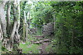
3
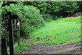
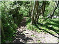
Hedgerow by public footpath
The path comes down hill from the camera crosses a track and goes to the kissing gate Image at footbridge over Jacob's Pill, but the path appears little used. The arms on the signpost indicate the route of the Pembrokeshire Coast Path.
Image: © M J Roscoe
Taken: 1 Aug 2023
0.14 miles
4
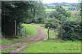
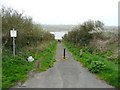
Footpath crossroads, Sykemoor, Pennar
One path continues along the track through the gate; the other path comes down hill by the signpost and continues to the right alongside the hedge Image The Coast Path comes down the track and turns to the left by the signpost.
Image: © M J Roscoe
Taken: 1 Aug 2023
0.15 miles
7
Ferry Road, Pennar
This led to Bentlass Ferry, which operated between two projecting bars of shingle. The lower end of the road has been closed to traffic. The sign states the penalties for fly-tipping, but this has not stopped someone from dumping an unwanted television.
Image: © Humphrey Bolton
Taken: 31 Mar 2011
0.17 miles
8
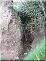
Mini-ravine near Ferry Road, Pennar
This little stream has cut a short ravine into the decaying old red sandstone, and enters it at a miniature waterfall.
Image: © Humphrey Bolton
Taken: 31 Mar 2011
0.17 miles
9
Ordnance Survey Cut Mark
This damaged OS cut mark can be found on the wall of the stile. It marks a point 24.369m above mean sea level.
Image: © Adrian Dust
Taken: 25 Mar 2022
0.17 miles
10
Kissing gate gate at gap in stone wall
The Coast Path leaves a short stretch of woodland and runs along the edge of a grass field. Wall has OS cut mark Image
Image: © M J Roscoe
Taken: 1 Aug 2023
0.17 miles