IMAGES TAKEN NEAR TO
Donovan Reed Gardens, PEMBROKE DOCK, SA72 6EW
Introduction
This page details the photographs taken nearby to Donovan Reed Gardens, SA72 6EW by members of the Geograph project.
The Geograph project started in 2005 with the aim of publishing, organising and preserving representative images for every square kilometre of Great Britain, Ireland and the Isle of Man.

There are currently over 7.5m images from over14,400 individuals and you can help contribute to the project by visiting https://www.geograph.org.uk
Image Map (Loading...)


Getting Data...Please wait
Leaflet Map data © OpenStreetMap
Images are licensed for reuse under creativecommons.org/licenses/by-sa/2.0
Notes
- Clicking on the map will re-center to the selected point.
- The higher the marker number, the further away the image location is from the centre of the postcode.
Image Listing (91 Images Found)
Images are licensed for reuse under creativecommons.org/licenses/by-sa/2.0
Image
Details
Distance
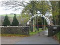
1
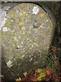
Boundary Stone
This BS can be found at the entrance to the cemetery. It has an OS cut mark on the front which marks a point 21.542m above mean sea level.
Image: © Adrian Dust
Taken: 31 Oct 2015
0.05 miles
3
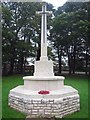
The Cross of Sacrifice in Military Cemetery Pembroke Dock
Image: © Arthur C Harris
Taken: 1 Oct 2017
0.06 miles
4
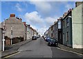
Arthur Street, Pembroke Dock
Viewed from the A4139 London Road end looking up towards Canterbury Road.
Image: © Jaggery
Taken: 13 Mar 2015
0.08 miles
5
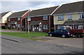
Charles Thomas Avenue houses, Pembroke Dock
The houses face the eastern perimeter wall of this http://www.geograph.org.uk/photo/4391922 rugby ground.
Image: © Jaggery
Taken: 13 Mar 2015
0.08 miles
6
Junction of Connaught Place with Essex Road
Image: © Ruth Sharville
Taken: 11 Feb 2009
0.09 miles
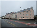
7
Pink housing, Pembroke Dock
The north side of a long row, viewed from the corner of Charles Thomas Avenue.
The dwellings have frontages alongside London Road.
Image: © Jaggery
Taken: 13 Mar 2015
0.10 miles
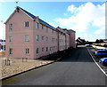
9
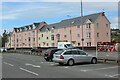
Apartment blocks on London Road
Pink and cream blocks of flats on A4139 viewed from Tesco car park.
Image: © M J Roscoe
Taken: 30 May 2022
0.11 miles
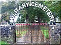
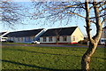
10
Military Cemetery
There is a GeoCache here for travel bugs.
Image: © Stephen Bashford
Taken: 27 Nov 2005
0.12 miles