IMAGES TAKEN NEAR TO
Devon Drive, PEMBROKE, SA71 5TS
Introduction
This page details the photographs taken nearby to Devon Drive, SA71 5TS by members of the Geograph project.
The Geograph project started in 2005 with the aim of publishing, organising and preserving representative images for every square kilometre of Great Britain, Ireland and the Isle of Man.

There are currently over 7.5m images from over14,400 individuals and you can help contribute to the project by visiting https://www.geograph.org.uk
Image Map (Loading...)


Getting Data...Please wait
Leaflet Map data © OpenStreetMap
Images are licensed for reuse under creativecommons.org/licenses/by-sa/2.0
Notes
- Clicking on the map will re-center to the selected point.
- The higher the marker number, the further away the image location is from the centre of the postcode.
Image Listing (12 Images Found)
Images are licensed for reuse under creativecommons.org/licenses/by-sa/2.0
Image
Details
Distance
1

Golden Hill Halt railway station (site), Pembrokeshire
Opened in 1909 by the Great Western Railway on the line from Whitland to Pembroke Dock, this station closed in 1940.
View south from the road. The halt was to the left of the bridge, with access to it by a now bricked-up entrance on the far side of the bridge, just before the railings.
Image: © Nigel Thompson
Taken: 18 May 2014
0.12 miles
2

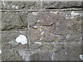
Ordnance Survey Cut Mark
This OS cut mark can be found on the wall NW side of Golden Hill. It marks a point 42.024m above mean sea level.
Image: © Adrian Dust
Taken: 22 Mar 2022
0.12 miles
3
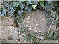
Ordnance Survey Cut Mark
This OS cut mark can be found on the NW buttress of the railway bridge on Golden Hill. It marks a point 25.345m above mean sea level.
Image: © Adrian Dust
Taken: 22 Mar 2022
0.13 miles
4
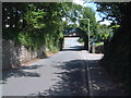
The road narrows for the railway bridge
The bridge is hidden by the trees.
Image: © David Medcalf
Taken: 8 Aug 2022
0.13 miles
5
Ordnance Survey Cut Mark
This OS cut mark can be found on the wall SE side of Golden Hill. It marks a point 56.200m above mean sea level.
Image: © Adrian Dust
Taken: 22 Mar 2022
0.14 miles
6
Golden Hill railway bridge
Very low bridge which has had several lorries and some buses stuck under it in the past.
Image: © TEIFION HUGHES
Taken: 2 Aug 2008
0.20 miles
7
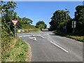
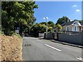
The junction with Buttermilk Lane
Buttermilk lane is shown as the minor road on the OS map, but it is the main road at the junction.
Image: © David Medcalf
Taken: 8 Aug 2022
0.21 miles
8
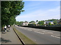
Bush Hill, Pembroke
Looking north opposite Whitehall Drive. National Cycle Network Route 4 runs parallel to the road here.
Image: © Simon Mortimer
Taken: 11 Aug 2012
0.23 miles
9

Ordnance Survey Cut Mark
This OS cut mark can be found on the wall NE side of Bush Hill. It marks a point 30.904m above mean sea level.
Image: © Adrian Dust
Taken: 22 Mar 2022
0.23 miles
10
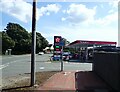
Ascona Green Garage and Service Station
At the junction of Castle View and The Green
Image: © Eirian Evans
Taken: 31 Aug 2022
0.24 miles