IMAGES TAKEN NEAR TO
Stackpole, PEMBROKE, SA71 5DQ
Introduction
This page details the photographs taken nearby to SA71 5DQ by members of the Geograph project.
The Geograph project started in 2005 with the aim of publishing, organising and preserving representative images for every square kilometre of Great Britain, Ireland and the Isle of Man.

There are currently over 7.5m images from over14,400 individuals and you can help contribute to the project by visiting https://www.geograph.org.uk
Image Map
Images are licensed for reuse under creativecommons.org/licenses/by-sa/2.0
Notes
- Clicking on the map will re-center to the selected point.
- The higher the marker number, the further away the image location is from the centre of the postcode.
Image Listing (20 Images Found)
Images are licensed for reuse under creativecommons.org/licenses/by-sa/2.0
Image
Details
Distance
2
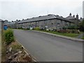
The Old Manor House, Stackpole Outdoor Learning Centre
The former Stackpole estate buildings are now owned by the National Tursus and have been converted for use as a field study centre and venue for weddings and other gatherings. The old manor house seen on the right here can be hired for residential accommodation.
Image: © Natasha Ceridwen de Chroustchoff
Taken: 7 Jul 2018
0.03 miles
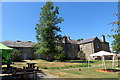
3
The Stackpole Centre
Near the site of the old mansion house
Image: © Deborah Tilley
Taken: 23 Jan 2015
0.05 miles
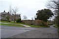
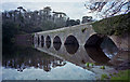
4
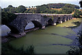
The bridge at Stackpole Centre
The eight arch bridge heading back through Stackpole Park
Image: © Alan Rolfe
Taken: Unknown
0.09 miles
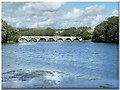
5
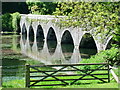
Eight arch bridge
The eight arch bridge that crosses the upper arm of the Bosherton Lily Ponds
Image: © Peter Levy
Taken: 25 May 2006
0.11 miles
6
Stackpole Eight Arched Bridge
Taken with the Olympus XA on Kodak Portra 400
Image: © Scott Lewis
Taken: 11 Dec 2011
0.15 miles
7
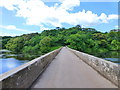
The bridge to the Old Manor House
This crosses the lily ponds near Bosherton
Image: © Raymond Knapman
Taken: 22 Jun 2015
0.16 miles
8

The eight arched bridge across Stackpole Lake
Image: © Dr Duncan Pepper
Taken: 7 Jul 2014
0.16 miles
9
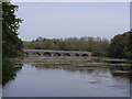
Eight Arch Bridge, Bosherton Lakes
The history of the Bosherston Lakes goes back to around 1760 when the Campbells of Stackpole Court began to lay out a picturesque landscape around their Georgian mansion. Sir John Campbell II dammed a river running through his estate to create three long, slender lakes, with a viewpoint over the lakes from the mansion. In 1797 an elegant bridge was built across one of the lakes to link the house and home farm with the deer park and Stackpole Quay. The Eight Arch Bridge is one of the focal points of Bosherston Lakes, and trails lead from the site of Stackpole Court on one side to Stackpole Warren on the other.
Image: © Colin Cheesman
Taken: 15 May 2019
0.17 miles
10
Bridge, Stackpole Centre
This 8-arch stone bridge crosses the Bosherston Lily Pond by Stackpole Centre. It is a Grade II* Listed Building - https://britishlistedbuildings.co.uk/300018003-eight-arch-bridge-stackpole#.YKRX9XmSmUk
Image: © Ian Taylor
Taken: 2 Aug 2004
0.17 miles