IMAGES TAKEN NEAR TO
Dolphin Rise, PEMBROKE, SA71 5AP
Introduction
This page details the photographs taken nearby to Dolphin Rise, SA71 5AP by members of the Geograph project.
The Geograph project started in 2005 with the aim of publishing, organising and preserving representative images for every square kilometre of Great Britain, Ireland and the Isle of Man.

There are currently over 7.5m images from over14,400 individuals and you can help contribute to the project by visiting https://www.geograph.org.uk
Image Map
Images are licensed for reuse under creativecommons.org/licenses/by-sa/2.0
Notes
- Clicking on the map will re-center to the selected point.
- The higher the marker number, the further away the image location is from the centre of the postcode.
Image Listing (188 Images Found)
Images are licensed for reuse under creativecommons.org/licenses/by-sa/2.0
Image
Details
Distance
3
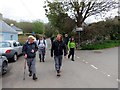
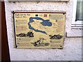
Pentre Angle Village
Cerddwyr yn cyrraedd pentre Angle.
Walkers arriving at Angle Village.
Image: © Alan Richards
Taken: 27 Apr 2014
0.04 miles
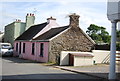
4
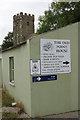
Signs at Angle
Turn right near the church for the Old Point House, a pub, and Angle lifeboat station.
Image: © Stephen McKay
Taken: 28 Aug 2017
0.04 miles
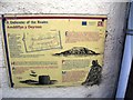
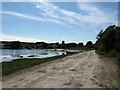
5
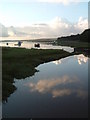
Angle Bay
An inlet of Angle Bay near the village of Angle.
Image: © Rob Farrow
Taken: 16 Aug 2004
0.05 miles
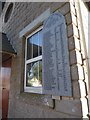
6
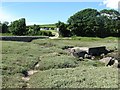
Ruins of the 1909 bridge
The date is engraved on the bridge (hard to see from this angle). A replacement bridge is behind on the left. In the background is Castle Farm campsite.
Image: © Colin Bell
Taken: 15 Jun 2008
0.05 miles