IMAGES TAKEN NEAR TO
Angle Road, PEMBROKE, SA71 4HS
Introduction
This page details the photographs taken nearby to Angle Road, SA71 4HS by members of the Geograph project.
The Geograph project started in 2005 with the aim of publishing, organising and preserving representative images for every square kilometre of Great Britain, Ireland and the Isle of Man.

There are currently over 7.5m images from over14,400 individuals and you can help contribute to the project by visiting https://www.geograph.org.uk
Image Map (Loading...)


Getting Data...Please wait
Leaflet Map data © OpenStreetMap
Images are licensed for reuse under creativecommons.org/licenses/by-sa/2.0
Notes
- Clicking on the map will re-center to the selected point.
- The higher the marker number, the further away the image location is from the centre of the postcode.
Image Listing (27 Images Found)
Images are licensed for reuse under creativecommons.org/licenses/by-sa/2.0
Image
Details
Distance
1
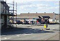
Spar Convenience Store, Monkton
With a handy bus stop nearby
Image: © Eirian Evans
Taken: 31 Aug 2022
0.04 miles
2
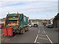
Long Mains, Monkton
It's bin day by the shop and post office at the top end of Long Mains.
Image: © Jonathan Wilkins
Taken: 29 Oct 2019
0.05 miles
3
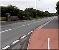
B4320 Monkton in Pembroke
Looking west along the B4320 Monkkton from the corner of Back Terrace.
An entrance http://www.geograph.org.uk/photo/3650090 to the Commonwealth War Graves cemetery is on the left.
Image: © Jaggery
Taken: 12 Sep 2013
0.05 miles
4
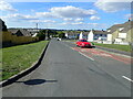
Long Mains, Monkton
Housing estate on the western edge of Pembroke. Monkton was largely redeveloped in the 1970s, providing housing for workers at the power station and oil refinery to the west. This view shows Long Mains with Montgomery Close leading off to the right.
Image: © Stephen McKay
Taken: 27 Aug 2017
0.06 miles
5
India Row, Monkton
India Row according to the road sign, but Adams Road on OS maps
Image: © Eirian Evans
Taken: 31 Aug 2022
0.08 miles
6

Monkton Church
We were staying in the Landmark Trust property "Monkton Old Hall" but this was in the same square as Pembroke Castle. The church wasn't though.
Image: © Stephen Bashford
Taken: 26 Nov 2005
0.12 miles
7
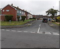
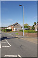
Montgomery Close, Monkton, Pembroke
Viewed across Back Lane.
Image: © Jaggery
Taken: 12 Sep 2013
0.13 miles
8
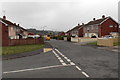
St Martins Road, Monkton, Pembroke
Viewed from the corner of Back Terrace.
Image: © Jaggery
Taken: 12 Sep 2013
0.13 miles
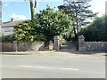
10
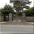
Northern entrance to the Commonwealth War Graves cemetery in Pembroke
Viewed from the B4320 Monkton.
Image: © Jaggery
Taken: 12 Sep 2013
0.15 miles