IMAGES TAKEN NEAR TO
Golden Lane, PEMBROKE, SA71 4BT
Introduction
This page details the photographs taken nearby to Golden Lane, SA71 4BT by members of the Geograph project.
The Geograph project started in 2005 with the aim of publishing, organising and preserving representative images for every square kilometre of Great Britain, Ireland and the Isle of Man.

There are currently over 7.5m images from over14,400 individuals and you can help contribute to the project by visiting https://www.geograph.org.uk
Image Map (Loading...)


Getting Data...Please wait
Leaflet Map data © OpenStreetMap
Images are licensed for reuse under creativecommons.org/licenses/by-sa/2.0
Notes
- Clicking on the map will re-center to the selected point.
- The higher the marker number, the further away the image location is from the centre of the postcode.
Image Listing (36 Images Found)
Images are licensed for reuse under creativecommons.org/licenses/by-sa/2.0
Image
Details
Distance
1
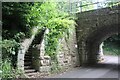
Steps on buttress of bridge, Golden Lane
The steps, on the west of the railway bridge Image, lead up to a locked access gate. There is an OS cutmark Image on the left hand stone pillar of the steps.
Image: © M J Roscoe
Taken: 10 Jul 2024
0.05 miles
2
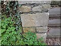
Ordnance Survey Cut Mark
This OS cut mark can be found on the wall NW side of Golden Lane. It marks a point 18.900m above mean sea level.
Image: © Adrian Dust
Taken: 22 Mar 2022
0.06 miles

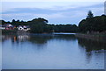
4
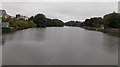
Mill Pond from Mill Bridge, Pembroke
Rather a large body of water for a pond! It extends for about 650 metres from this side of Mill Bridge and averages about 80 metres wide.
Image: © Jaggery
Taken: 12 Sep 2013
0.15 miles
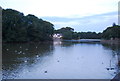
6
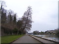
Pembroke Mill Pond - path and leaning tree
Image: © welshbabe
Taken: 22 Mar 2016
0.19 miles
7
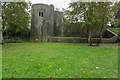
Barnard's Tower
A 13th Century three storeyed spur-tower overlooking the Mill Pond. One of six towers which at one time flanked the Pembroke town walls.
Image: © Guy Wareham
Taken: 18 Oct 2014
0.20 miles