IMAGES TAKEN NEAR TO
Holyland Road, PEMBROKE, SA71 4BL
Introduction
This page details the photographs taken nearby to Holyland Road, SA71 4BL by members of the Geograph project.
The Geograph project started in 2005 with the aim of publishing, organising and preserving representative images for every square kilometre of Great Britain, Ireland and the Isle of Man.

There are currently over 7.5m images from over14,400 individuals and you can help contribute to the project by visiting https://www.geograph.org.uk
Image Map
Images are licensed for reuse under creativecommons.org/licenses/by-sa/2.0
Notes
- Clicking on the map will re-center to the selected point.
- The higher the marker number, the further away the image location is from the centre of the postcode.
Image Listing (159 Images Found)
Images are licensed for reuse under creativecommons.org/licenses/by-sa/2.0
Image
Details
Distance
1

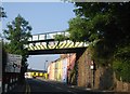
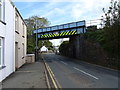
Railway bridge over the A4075, Pembroke
Viewed from Harcourt Terrace looking along the A4075 Holyland Road.
The bridge carries the single-track Pembroke Dock branch of the West Wales Line, about 100 metres NW of Pembroke railway station. Headroom shown is 4.5m (15 feet).
Image: © Jaggery
Taken: 12 Sep 2013
0.08 miles
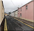
2
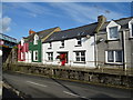
Harcourt Terrace, Pembroke
Harcourt Terrace is a separately-named row of houses alongside the A4075 Holyland Road. The bridge http://www.geograph.org.uk/photo/3650907 carries the single-track Pembroke Dock branch of the West Wales Line, about 100 metres NW of Pembroke railway station.
Image: © Jaggery
Taken: 12 Sep 2013
0.08 miles
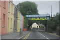
4
Railway bridge over Holyland Road, Pembroke
Image: © JThomas
Taken: 16 Oct 2019
0.08 miles
6

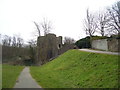
Ordnance Survey Cut Mark
This OS cut mark can be found on the SW buttress of the railway bridge on Holyland Road. It marks a point 14.251m above mean sea level.
Image: © Adrian Dust
Taken: 22 Mar 2022
0.09 miles
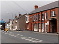
7
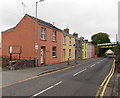
Orchard Buildings Pembroke
The street name signs shows ORCHARD BUILDINGS LEADING TO ORCHARD GARDENS.
Viewed from the corner of Station Road.
Image: © Jaggery
Taken: 12 Sep 2013
0.10 miles
8
Entrance to MDL Auto Services in Pembroke
Looking across Station Road towards the entrance on the right.
Image: © Jaggery
Taken: 12 Sep 2013
0.10 miles