IMAGES TAKEN NEAR TO
Jameston, TENBY, SA70 8QJ
Introduction
This page details the photographs taken nearby to SA70 8QJ by members of the Geograph project.
The Geograph project started in 2005 with the aim of publishing, organising and preserving representative images for every square kilometre of Great Britain, Ireland and the Isle of Man.

There are currently over 7.5m images from over14,400 individuals and you can help contribute to the project by visiting https://www.geograph.org.uk
Image Map
Images are licensed for reuse under creativecommons.org/licenses/by-sa/2.0
Notes
- Clicking on the map will re-center to the selected point.
- The higher the marker number, the further away the image location is from the centre of the postcode.
Image Listing (14 Images Found)
Images are licensed for reuse under creativecommons.org/licenses/by-sa/2.0
Image
Details
Distance
2
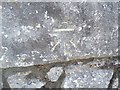
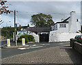
Ordnance Survey Cut Mark
This OS cut mark can be found on the wall north side of the entrance of the Swanlake Inn. It marks a point 62.505m above mean sea level.
Image: © Adrian Dust
Taken: 27 Apr 2019
0.06 miles
3
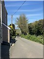
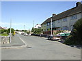
Road to Beaver’s Hill
Leaving Jameston.
Image: © Alan Hughes
Taken: 25 Apr 2023
0.07 miles
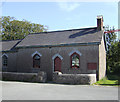
6
Council houses, Jameston
The gable end of the ex-chapel (minus bell) can be seen at the end of the street.
Image: © Jonathan Billinger
Taken: 9 Aug 2007
0.09 miles
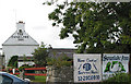
8
Jameston Community Hall
Temporary venue for Manorbier School children following a fire last October.
Image: © Alan Hughes
Taken: 25 Apr 2023
0.09 miles
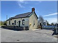
10
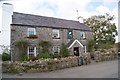
Former chapel, Jameston
Now converted to a house.
Image: © Jonathan Billinger
Taken: 9 Aug 2007
0.12 miles