IMAGES TAKEN NEAR TO
The Glen, SAUNDERSFOOT, SA69 9NR
Introduction
This page details the photographs taken nearby to The Glen, SA69 9NR by members of the Geograph project.
The Geograph project started in 2005 with the aim of publishing, organising and preserving representative images for every square kilometre of Great Britain, Ireland and the Isle of Man.

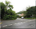
There are currently over 7.5m images from over14,400 individuals and you can help contribute to the project by visiting https://www.geograph.org.uk
Image Map
Images are licensed for reuse under creativecommons.org/licenses/by-sa/2.0
Notes
- Clicking on the map will re-center to the selected point.
- The higher the marker number, the further away the image location is from the centre of the postcode.
Image Listing (278 Images Found)
Images are licensed for reuse under creativecommons.org/licenses/by-sa/2.0
Image
Details
Distance
1
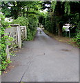
Pen y Graig, Saundersfoot
Pen y Graig is a dead-end lane extending for 85 metres from The Glen near the B4316 junction.
Image: © Jaggery
Taken: 16 Jul 2016
0.03 miles
2
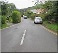
The Glen, Saundersfoot
Road descending from the southeast side of the B4316.
A nearby sign shows that The Glen is part of the Pembrokeshire Coast Path and the Wales Coast Path.
Image: © Jaggery
Taken: 16 Jul 2016
0.04 miles
4
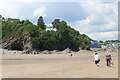
House on wooded cliff, Saundersfoot
White house overlooking beach; the Centre of Marine excellence is to the right of the woodland.
Image: © M J Roscoe
Taken: 29 May 2022
0.04 miles
5
B4316 junctions, Saundersfoot
On the east side of the B4316. The Glen http://www.geograph.org.uk/photo/5044744 is on the right, Pen y graig http://www.geograph.org.uk/photo/5044814 on the left.
Image: © Jaggery
Taken: 16 Jul 2016
0.05 miles
6
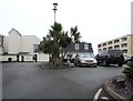
St Brides Spa Hotel, Saundersfoot
Viewed from the entrance from the B4316 St Brides Hill above Saundersfoot Bay.
Image: © Jaggery
Taken: 16 Jul 2016
0.05 miles
7
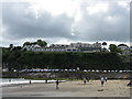
Saundersfoot - Beach & Apartments
The apartments on the cliff are on Captain's Walk, with fine views over the harbour and beach.
Image: © Peter Whatley
Taken: 19 Jul 2009
0.06 miles
8
Coast Path signpost, The Glen, Saundersfoot
On the right here, http://www.geograph.org.uk/photo/5044874 the signpost arm points left towards
the Pembrokeshire Coast Path, part of the Wales Coast Path.
Image: © Jaggery
Taken: 16 Jul 2016
0.06 miles
9
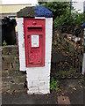
King George V postbox outside Claremont House, Saundersfoot
Located here. http://www.geograph.org.uk/photo/5044846 The GR on the box is short for Georgius Rex, Latin
for King George, in this case King George V who reigned from May 1910-January 1936
Image: © Jaggery
Taken: 16 Jul 2016
0.06 miles
10
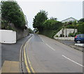
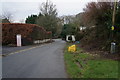
No parking on the B4316 St Brides Hill, Saundersfoot
Double yellow lines on both sides of the road indicate no parking at any time.
Image: © Jaggery
Taken: 16 Jul 2016
0.06 miles