IMAGES TAKEN NEAR TO
Cynon Close, SWANSEA, SA6 8QA
Introduction
This page details the photographs taken nearby to Cynon Close, SA6 8QA by members of the Geograph project.
The Geograph project started in 2005 with the aim of publishing, organising and preserving representative images for every square kilometre of Great Britain, Ireland and the Isle of Man.

There are currently over 7.5m images from over14,400 individuals and you can help contribute to the project by visiting https://www.geograph.org.uk
Image Map
Images are licensed for reuse under creativecommons.org/licenses/by-sa/2.0
Notes
- Clicking on the map will re-center to the selected point.
- The higher the marker number, the further away the image location is from the centre of the postcode.
Image Listing (7 Images Found)
Images are licensed for reuse under creativecommons.org/licenses/by-sa/2.0
Image
Details
Distance
1
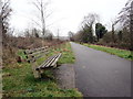
Llwybr beicio ger Treforus / Cycle path near Morriston
Llwybr becio ar lan Afon Tawe ger Treforus.
A cycle path above the Tawe river near Morriston.
Image: © Alan Richards
Taken: 8 Jan 2020
0.13 miles
2
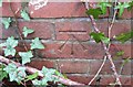
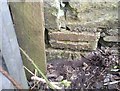
Ordnance Survey Cut Mark
This OS cut mark can be found on the Inspection Chamber surround south side of the path. It marks a point 6.416m above mean sea level.
Image: © Adrian Dust
Taken: 14 Apr 2019
0.14 miles
3
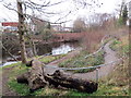
Llwybr i'r afon / Path to the river
Llwybr yn arwain i lawr o'r trac beicio at lannau Afon Tawe.
A path leading down from the cycle track towards the banks of the Tawe River.
Image: © Alan Richards
Taken: 8 Jan 2020
0.14 miles
4
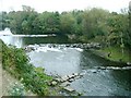
Weirs on the river Tawe
Taken from the high west bank near a residential street. There is a cycle path along the east bank which can be joined from Ferryboat road. The difference in height between the banks here makes me question whether there was ever really a ferry though.
Image: © Nigel Davies
Taken: 14 Oct 2007
0.15 miles
5
Ordnance Survey Cut Mark
This OS cut mark can be found on the SE angle of the old works building east side of the road. It marks a point 14.109m above mean sea level.
Image: © Adrian Dust
Taken: 14 Apr 2019
0.21 miles
6
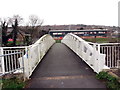
Pont Newydd Beaufort/ New Beaufort Bridge
Pont Newydd Beaufort yn rhychwantu Afon Tywi. Codwyd y bont hon yn 2013 fel rhan o gynllun £7m i atal llifogydd yn yr ardal. Adeiladwyd y bont ar hen safle neu'n agos i strwythur a godwyd yn c1747 gan y adeiladwr pont enwog William Edwards ac fe'i dymchwelwyd yn c1968.
Built in 2013 the new Beuafort Bridge was part of a £7m flood prevention scheme for the area. The old Beaufort Bridge, built in c1747 by William Edwards, the well known bridge builder, was demolished around 1968.
Image: © Alan Richards
Taken: 8 Jan 2020
0.21 miles
7

Young Coot calling on Fendrod Lake, Swansea
Image: © Ruth Sharville
Taken: 6 Jul 2010
0.24 miles