IMAGES TAKEN NEAR TO
Trewyddfa Road, SWANSEA, SA6 8NX
Introduction
This page details the photographs taken nearby to Trewyddfa Road, SA6 8NX by members of the Geograph project.
The Geograph project started in 2005 with the aim of publishing, organising and preserving representative images for every square kilometre of Great Britain, Ireland and the Isle of Man.

There are currently over 7.5m images from over14,400 individuals and you can help contribute to the project by visiting https://www.geograph.org.uk
Image Map (Loading...)


Getting Data...Please wait
Leaflet Map data © OpenStreetMap
Images are licensed for reuse under creativecommons.org/licenses/by-sa/2.0
Notes
- Clicking on the map will re-center to the selected point.
- The higher the marker number, the further away the image location is from the centre of the postcode.
Image Listing (51 Images Found)
Images are licensed for reuse under creativecommons.org/licenses/by-sa/2.0
Image
Details
Distance
1
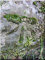
Ordnance Survey Cut Mark
This moss covered OS cut mark can be found on the wall of No.11 Cnap Llwyd. It and the stone on which it was carved originally would have been part of the NW angle of the house. The house being rebuilt and the stone ending up as part of the boundary wall. When in the house wall it would have marked a point 101.788m above sea level.
Image: © Adrian Dust
Taken: 22 Jan 2014
0.06 miles
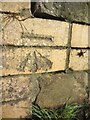
2
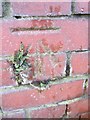
Ordnance Survey Cut Mark
This OS cut mark can be found on the wall of No15 Emlyn Terrace. It marks a point 62.198m above mean sea level.
Image: © Adrian Dust
Taken: 22 Jan 2014
0.08 miles
4
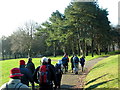
Parc Llewelyn Park
Cerddwyr yn mynd drwy Barc Llewelyn a agrowyd yn 1878. Rhoddwyd y tir ar Ffarm Cnap Llwyd gan y cyfoethog John Dillwyn Llewelyn o Blas Penllergaer.
Walkers going through Parc Llewelyn which was opened in 1878. The land on Cnap Llwyd Farm (trans. brown hill) was donated by the wealthy John Dillwyn Llewelyn of Penllergaer Mansion.
Image: © Alan Richards
Taken: 28 Dec 2008
0.16 miles
5
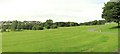
Llewelyn Park
A large and sprawling park on a hillside.
Image: © Nigel Davies
Taken: 31 Jul 2005
0.16 miles
6
Ordnance Survey Cut Mark
This OS cut mark can be found on what once was the gatepost of No1 Gelli Terrace. It marks a point 70.659m above mean sea level.
Image: © Adrian Dust
Taken: 22 Jan 2014
0.18 miles
7
The ruins of 'Morris Castle' seen from Cwmgelli Close
Image: © john bristow
Taken: 18 Jun 2021
0.18 miles
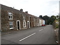
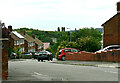
8
Britannia Road houses, Plasmarl, Swansea
Alongside the ascent from the B4603 Neath Road in the Plasmarl area of Swansea.
Image: © Jaggery
Taken: 12 Nov 2018
0.19 miles
9
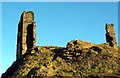
Castell Graig / Morris Castle
Er iddo ddisgwl fel adfail castell o'r Canol Oesoedd adeiladwyd Castell Graig, fel y'i gelwir, rhwng 1768-1775 gan John Morris i gartrefu rhai o'i lowyr a'u teuluodd. Dywedir y bu gan yr adeilad bedwar llawr a 24 o fflatiau. Erbyn 1880 roedd e wedi mynd a'i ben iddo.
Despite having the appearance of a medieval fortification, Morris Castle or Castle Graig, was built between 1768-1775 by John Morris to house some of his colliers and their families. The building consisted of four floors and a total of 24 compartments. It had become ruinous by 1880.
Image: © Alan Richards
Taken: 28 Dec 2008
0.19 miles
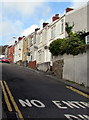
10
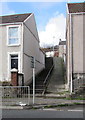
Steps and path up from Neath Road, Plasmarl, Swansea
Ascending towards Dinas Street.
Image: © Jaggery
Taken: 12 Nov 2018
0.19 miles