IMAGES TAKEN NEAR TO
Newton Fields, KILGETTY, SA68 0ZA
Introduction
This page details the photographs taken nearby to Newton Fields, SA68 0ZA by members of the Geograph project.
The Geograph project started in 2005 with the aim of publishing, organising and preserving representative images for every square kilometre of Great Britain, Ireland and the Isle of Man.

There are currently over 7.5m images from over14,400 individuals and you can help contribute to the project by visiting https://www.geograph.org.uk
Image Map (Loading...)


Getting Data...Please wait
Leaflet Map data © OpenStreetMap
Images are licensed for reuse under creativecommons.org/licenses/by-sa/2.0
Notes
- Clicking on the map will re-center to the selected point.
- The higher the marker number, the further away the image location is from the centre of the postcode.
Image Listing (55 Images Found)
Images are licensed for reuse under creativecommons.org/licenses/by-sa/2.0
Image
Details
Distance
1
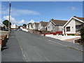
Ash Park - Main Section
A stiff climb up the hillside awaits the mainly elderly residents of this 1970s estate.
Image: © Peter Whatley
Taken: 18 Jul 2009
0.09 miles
2

Ash Park - Top Section
One of several 1970s housing estates west of Kilgetty's centre.
Image: © Peter Whatley
Taken: 18 Jul 2009
0.09 miles
3
Ash Park, Kilgetty
Cul-de-sac on the north side of Carmarthen Road.
Image: © Jaggery
Taken: 19 Jan 2018
0.12 miles
4

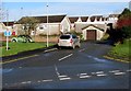
Station Garage Kilgetty
On the north side of Carmarthen Road.
Image: © Jaggery
Taken: 19 Jan 2018
0.14 miles
5
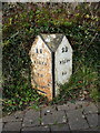
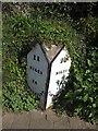
The Kilgetty milestone
Situated on the north side of the road, more or less opposite the Co-op, and recording 11 miles to Hobb's Point and 22 miles to Carmarthen. It was only when a resident saw my interest asked me if I had spotted the 'flaw' in these mileages that the penny dropped - the milestone is now on the wrong side of the road; Carmarthen is to the east of here (ie off to the right) so that plate should have been legible as you approached the stone. Hence it started life on the south side of the road, and has been repositioned at some stage.
Image: © Richard Law
Taken: 23 Dec 2019
0.14 miles
6
James Park, Kilgetty
From the north side of Carmarthen Road, the road named James Park leads to Cotswold Gardens and Kingsmoor Sports & Social Club.
Image: © Jaggery
Taken: 19 Jan 2018
0.15 miles
7
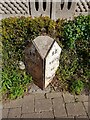
Old Milestone by Carmarthen Road, Kilgetty/Cilgeti
Pembroke double plate by the UC road (was A477), in parish of Kilgetty/Cilgeti (Pembrokeshire District), opposite Kilkenny Co-op.
Inscription reads:-
: 11 / MILES / TO / HOBB'S POINT : : 22 / MILES / TO / CARMARTHEN :
Grade II listed by Cadw.
Reference Number: 87800 https://cadwpublic-api.azurewebsites.net/reports/listedbuilding/FullReport?lang=&id=87800
Surveyed
Milestone Society National ID: PEM_CMHP22
Image: © Milestone Society
Taken: Unknown
0.15 miles
8
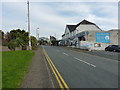
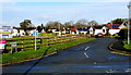
Along the main road through Kilgetty
This was once the A477 between St Clears and Pembroke, before the village of Kilgetty was bypassed. The Co-op occupies the building on the right.
Image: © Richard Law
Taken: 23 Dec 2019
0.15 miles
10
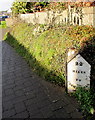
Old milepost in Kilgetty 22 miles from Carmarthen
On the north side of Carmarthen Road opposite the Co-op. https://www.geograph.org.uk/photo/5646281
Image: © Jaggery
Taken: 19 Jan 2018
0.15 miles