IMAGES TAKEN NEAR TO
Fir Grove, KILGETTY, SA68 0XD
Introduction
This page details the photographs taken nearby to Fir Grove, SA68 0XD by members of the Geograph project.
The Geograph project started in 2005 with the aim of publishing, organising and preserving representative images for every square kilometre of Great Britain, Ireland and the Isle of Man.

There are currently over 7.5m images from over14,400 individuals and you can help contribute to the project by visiting https://www.geograph.org.uk
Image Map (Loading...)


Getting Data...Please wait
Leaflet Map data © OpenStreetMap
Images are licensed for reuse under creativecommons.org/licenses/by-sa/2.0
Notes
- Clicking on the map will re-center to the selected point.
- The higher the marker number, the further away the image location is from the centre of the postcode.
Image Listing (26 Images Found)
Images are licensed for reuse under creativecommons.org/licenses/by-sa/2.0
Image
Details
Distance
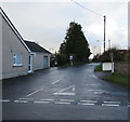
1
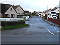
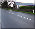
Fir Grove, Begelly
Cul-de-sac on the west side of the A478.
Image: © Jaggery
Taken: 19 Jan 2018
0.01 miles
2
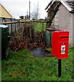
Queen Elizabeth II postbox alongside the A478, Begelly
Located on the left here https://www.geograph.org.uk/photo/5656527 near Begelly Stores.
Image: © Jaggery
Taken: 19 Jan 2018
0.04 miles
3
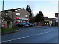
Begelly Stores and Signsmart, Begelly
Set back from the west side of the A478 near the northern edge of the Pembrokeshire village.
Image: © Jaggery
Taken: 19 Jan 2018
0.04 miles
4

Begelly Stores and Signsmart, Begelly
Set back from the west side of the A478 near the northern edge of the Pembrokeshire village.
Image: © Jaggery
Taken: 19 Jan 2018
0.04 miles
5
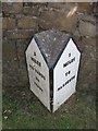
Old Milestone by the A478, Begelly
Pembroke double plate by the A478, in parish of Kilgetty/Begelly (Pembrokeshire District), Begelly, North of village, against wall, East side of road.
Inscription reads:-
: 5 MILES / 970 YARDS / TO / TENBY : : 5 / MILES / TO / NARBERTH :
Grade II listed by Cadw.
Reference Number: 87799 https://cadwpublic-api-staging.azurewebsites.net/reports/listedbuilding/FullReport?lang=&id=87799
Surveyed
Milestone Society National ID: PEM_TBNB05
Image: © Milestone Society
Taken: Unknown
0.05 miles
6
Old milestone alongside the A478 in Begelly
Located roughly midway between Tenby and Narberth. https://www.geograph.org.uk/photo/5657075 to a closer view.
Image: © Jaggery
Taken: 19 Jan 2018
0.05 miles
7
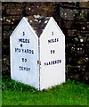
Milestone detail, Begelly
Located alongside the A478 https://www.geograph.org.uk/photo/5657065 5 miles from Narberth and 5 miles 970 yards from Tenby.
The reason for the great precision of the Tenby distance is unclear to this observer,
and great precision is not the same as great accuracy. To which location in Tenby does this refer?
Image: © Jaggery
Taken: 19 Jan 2018
0.05 miles
8
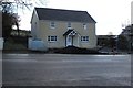
Recently-built house in the north of Begelly, Pembrokeshire
On the east side of the A478 between Fir Grove and Broom Lane viewed in January 2018.
Image: © Jaggery
Taken: 19 Jan 2018
0.05 miles
9
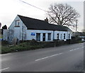
White houses in the north of Begelly, Pembrokeshire
On the east side of the A478 between Fir Grove and Broom Lane.
Image: © Jaggery
Taken: 19 Jan 2018
0.06 miles
10
West along Broom Lane, Begelly
From the A478, Broom Lane leads to the hamlet of Thomas Chapel.
Image: © Jaggery
Taken: 19 Jan 2018
0.06 miles