IMAGES TAKEN NEAR TO
Heritage Gardens, KILGETTY, SA68 0TW
Introduction
This page details the photographs taken nearby to Heritage Gardens, SA68 0TW by members of the Geograph project.
The Geograph project started in 2005 with the aim of publishing, organising and preserving representative images for every square kilometre of Great Britain, Ireland and the Isle of Man.

There are currently over 7.5m images from over14,400 individuals and you can help contribute to the project by visiting https://www.geograph.org.uk
Image Map
Images are licensed for reuse under creativecommons.org/licenses/by-sa/2.0
Notes
- Clicking on the map will re-center to the selected point.
- The higher the marker number, the further away the image location is from the centre of the postcode.
Image Listing (77 Images Found)
Images are licensed for reuse under creativecommons.org/licenses/by-sa/2.0
Image
Details
Distance
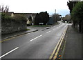
1

Heritage Gardens, Kilgetty
Cul-de-sac on the west side of Ryelands Lane.
Image: © Jaggery
Taken: 6 Jan 2018
0.01 miles
2

Kilgetty WI Hall, Ryelands Lane, Kilgetty
The WI (Women's Institute) Hall is a corrugated metal building opposite Oakfield Drive.
Image: © Jaggery
Taken: 6 Jan 2018
0.02 miles
3
Ryelands Lane, Kilgetty
North along Ryelands Lane from the corner of Carmarthen Road. The left turn is into Heritage Gardens. https://www.geograph.org.uk/photo/5644737
Image: © Jaggery
Taken: 6 Jan 2018
0.03 miles
4
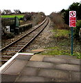
Railway north from Kilgetty towards Narberth
The single-track Pembroke Dock branch of the West Wales Line viewed from Kilgetty Station https://www.geograph.org.uk/photo/5645897.
In the foreground the railway crosses the bridge over Carmarthen Road.
The next station, about 9km ahead, is Narberth https://www.geograph.org.uk/photo/4593011 on the route to Whitland, Carmarthen and Swansea.
Image: © Jaggery
Taken: 6 Jan 2018
0.03 miles
5
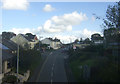
Carmarthen Road, Kilgetty
Uphill from the railway station.
Image: © JThomas
Taken: 16 Oct 2019
0.04 miles

7

OS benchmark - Kilgetty, railway bridge buttress
An OS cutmark on the NW face of the railway bridge buttress; originally levelled in 1970 at 69.178m above Ordnance Datum Newlyn.
Image: © Richard Law
Taken: 24 Dec 2019
0.04 miles
8
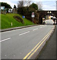
Carmarthen Road descends towards a railway bridge, Kilgetty
The bridge is immediately northwest of Kilgetty railway station.
Turquoise information boards https://www.geograph.org.uk/photo/5646007 at the station entrance are on the left.
Image: © Jaggery
Taken: 6 Jan 2018
0.04 miles
9
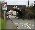
East side of Carmarthen Road railway bridge, Kilgetty
Headroom shown over the middle part of the bridge is 13' 0" and 3.96 metres.
Traffic on this side must give way to oncoming vehicles. The text is also in Welsh.
Stop behind the broken white lines until the road under the bridge is clear.
Image: © Jaggery
Taken: 6 Jan 2018
0.04 miles
10

Kilgetty railway station name sign
The sign on the corner of Carmarthen Road and Shillingford Park shows that Kilgetty is Cilgeti in Welsh. Turquoise information boards https://www.geograph.org.uk/photo/5646007 at the station entrance are on the right.
Image: © Jaggery
Taken: 6 Jan 2018
0.04 miles